UK Monuments:
Cardington - R-101 *
Shortstown - R-101 *
Shortstown - RAF Cardington *
Hull - R-38 *
Elloughton - R-38 *
East Fortune - R-34 *
Edinburgh Scotland *
Renfrew - R-34 *
London *
Braintree *
Appleton - Zeppelin bombing *
Essendon - Church bombed by Zeppelin *
Cuffley - SL-11 Shoot-down *
Sheringham - L-4 Bombing *
Great Yarmouth - L-3 Bombing![]() *
Little Wigborough - Landing site of the L-33 *
Billericay - Downing of the L-32 *
Cannock - Zeppelin Graves *
Pembroke - RNAS Milton *
Cardiff - Willows Clock Tower *
Cardiff - Willows Gravesite *
"The Ernest Willows" pub - Cardiff
*
Little Wigborough - Landing site of the L-33 *
Billericay - Downing of the L-32 *
Cannock - Zeppelin Graves *
Pembroke - RNAS Milton *
Cardiff - Willows Clock Tower *
Cardiff - Willows Gravesite *
"The Ernest Willows" pub - Cardiff
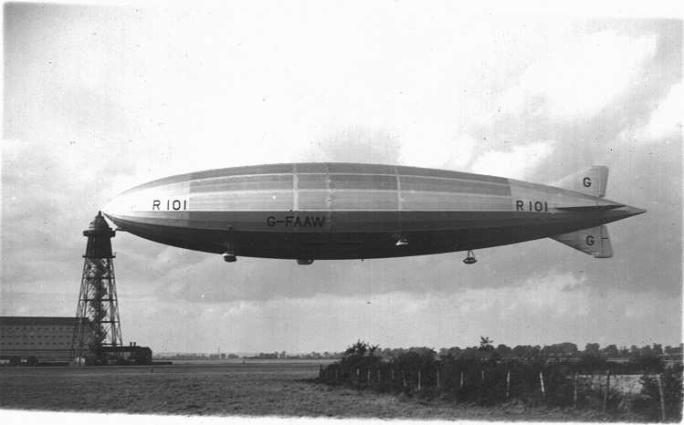
The United Kingdom has a rich history in Airships. The grand R-100 and R-101 hail to Great Britain, as well the R-34, and Ernest Willows, known as "The Father of British Airships". There are a few memorials to airships I've located in the UK.
Cardington - Memorial to the R-101:
Photo credit: Public domain
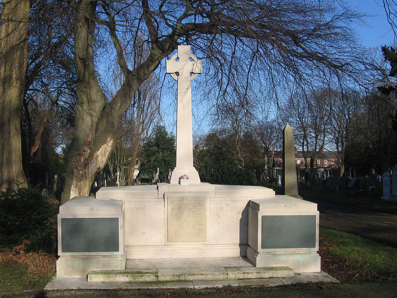
A monument to the R-101 and her crew is at the St. Mary's church cemetery in Cardington. This is both a monument and a gravesite. All the 48 dead from the 5 October, 1930 disaster are buried in one grave here and the names of all are inscribed on the memorial - 24 on one side, 24 on the other.
Photo credit: Waymarking.com, Undetermined
It is a very nice memorial, with an inscription of the names of the deceased and on the south side of the monument the inscription reads: "Here lie the bodies of 48 officers and men who perished in H.M. Airship R 101 at Beauvais France Oct. 5, 1930."
The exact location is (Lat Lon) 52.119524 -000.416366, Cardington. Here is the location in Google Maps:
Shortstown - Memorial to Shortstown crewmembers of the R-101:
This memorial to the R-101 and her Shortstown crew is at Shortstown, just west of the Cardington Airship Sheds. This memorial was dedicated April 19, 2017. The community was originally built in 1917 by Short Brothers for its workers at the Airship Works, but expanded into a settlement for people working at the RAF Cardington base.
Photo credit: britishairshippeople.org.uk/shortstown-airship-village/4594544803 (site is probably safe but insecure.)
Photo credit: shortstownheritage.co.uk (Website broken as of March, 2020)
The location is (Lat Lon) 52.107054 -000.429907, in the sports fields of Shortstown, nearest the Cardington airship sheds which remain dominant in the area still today, yet still the site of airship activity. Here is the location in Google Maps:
Shortstown - Memorial to Honor RAF crews who served at Cardington:
This memorial is at the Shorts Building in Shortstown, the site of the RAF Airships Works Administration building built in 1917. This memorial was dedicated May 18, 2019. The community was originally built in 1917 by Short Brothers for its workers at the Airship Works, but expanded into a settlement for people working at the RAF Cardington base.
Photo credit: https://www.airshipsonline.com/sheds/Cardington.htm
Photo credit: https://www.airshipsonline.com/sheds/Cardington.htm
The location is (Lat Lon) 52.111416 -000.431386, in the West-side grounds of the restored, refurbished, and in-use Shorts Building. The the Cardington airship sheds are just 1/2 mile to the SE of the new commemorative marker to the men and women of the RAF so even though this is not a "major" monument, the history of the area and the Cardington sheds nearby make this area a great place to visit for the airship fanatic. Here is the location of the marker in Google Maps:
Hull - Memorial to the R-38:
This monument at the Hull Western Cemetery is dedicated to the loss of the airship and the 44 men of the R-38. The R-38 was to become the "ZR-2" of the United States Navy. She was already painted on the side with the "ZR-2" and carried the US Navy roundel.
The R-38/ZR-2 was lost on 24 August, 1921 when the airframe failed during rigorous testing for its American observers who were on-board. The R-38 broke apart and fell into the Humber river. Forty-four of the 49 crewmembers perished.
Photo credit: Keith D., Wikimedia
It is a very nice memorial, with an inscription of the deceased. Nine of the 44 who dies are buried under the memorial. All the American victims were returned to the US. Read more at Roll-of-Honour.com
The exact location is (Lat Lon) 53.751276 -000.376326, Hull. Here is the location in Google Maps:
Elloughton - Commemoration to the US Navy Officers on the R-38/ZR-2:
Photo credit: airfieldarchaeology.co.uk, Unknown
At the St. Mary the Virgin Church in Elloughton there is a small dedication to the senior US Navy officers who died in the R38/ZR-2 airship crash. The plaque is inside the Church.
The coordinates of the church are (Lat Lon) 53.741901 -000.569712, located here in Google Maps:
East Fortune, Scotland - Commemoration to the R-34 Atlantic Crossing:
Photo credit: Public domain
There is a small monument to commemorate the crossing of the Atlantic by the R-34 which departed from East Fortune, Scotland on 2 July, 1919, and landed at Mineola, New York on 6 July, 1919, and returned to Pulham England on 13 July, 1919.
Photo credit: Undetermined
Just as with the duplicate monument in the USA, this marker is relocated from where it originally stood, presumably for the convenience of the museum caretakers. This marker is now located here:
Photo credit: Google Earth
The left-most red arrow points to an airship mooring block, also relocated from its original position, and the right-most red arrow points to the R-34 marker:
Photo credit: Combined from: https://bikelove-scotland.blogspot.com/2011/08/national-museum-of-flight-military.html
The exact location within the air park at (Lat Lon) 55.994808 -002.719699, East Fortune, Scotland. Here is the location in Google Maps:
(There is a duplicate plaque placed at the US landing site of the R-34 in Mineola, New York, but sadly, New York also did not preserve the original location of the marker. The US marker is now inside the "Cradle of Aviation" museum on Long Island, New York, inaccessible unless paying admission to the museum. Here is a direct link to the location of the US marker: R-34 Marker-US)
Edinburgh Scotland Zeppelin Flagstone
There is a pavement marker in Edinburgh commemorating the site of a Zeppelin bombing on April 2nd, 1916. The marker is in an area known as Grassmarket.
Photo credit: Kim Traynor
Here is a street view with an arrow pointing to the marker:
Photo credit: Google Streetview
The exact location is in the area of (Lat Lon) 55.947343 -003.196456. Here is the location in Google Maps:
Clyde View Park, Renfrew, Scotland: R-34 Pillar
There is a small monument the R-34 located at the Clyde View Park, Renfrew, Scotland.
Photo credit: Undetermined
Detail of the inscription:
Photo credit: Undetermined
The exact location within the park id (Lat Lon) 55.881191 -004.377398. Here is the location in Google Maps:
London Zeppelin Raid House
There is a marker on a property in London commemorating the Zeppelin raid of September 8, 1915.
Photo credit: Undetermined
Here is a street view with an arrow pointing to the marker:
Photo credit: Google Streetview
The exact location is at (Lat Lon) 51.520721 -000.106074. Here is the location in Google Maps:
Braintree Zeppelin Bombing House
There is a marker on a property in Braintree commemorating the Zeppelin bombing of March 31, 1916.
Photo credit: Undetermined
Here is a street view with an arrow pointing to the marker. (This is a private residence, so I would caution anyone going to the site, be respectful and leave the residents at peace):
Photo credit: Echo News
Here is the destruction in 1916:
Photo credit: Public domain
The exact location is at (Lat Lon) 51.876252 000.549914. Here is the location in Google Maps:
Appleton (east of Liverpool) Zeppelin Bombing
This is an interesting "find"! Near the end of WW I, the "final" Zeppelin raids over the UK took place. One of those raids was over the area of the Northern UK, east of Liverpool on April 12th, 1918. The night was dark and overcast. Given the dark night, and the fact that the people of the various communities respected the official blackout, Zeppelin navigation was difficult! But the light from blast furnaces of the "Wigan Coal and Iron Company", which had not received the air raid warning, attracted the Zeppelin L-61. The crew of the L-61 dropped several bombs one of which killed 7 people and injured 12 others at Wigan and a 4 others were injured at Aspull.
Additionally, a bomb landed near a "milestone" (literally a large stone mile-marker!) along the Prescot to Warrington road at Bold, damaging the milestone and the roadway. But the milestone was retained as a commemoration of the bombing! The milestone was removed from its original location and today it is in "Victoria Park" at Widnes as a reminder of the Zeppelin raid. Locals apparently refer to the milestone as the "Zeppelin Stone."
Photo credit: David Dixon
Two bronze plaques are positioned at the foot of the milestone to explain! (Click on the image for a larger version which you may be able to read):
Photo credit: David Dixon
The exact location of the milestone is at (Lat Lon) 53.372768 002.731293. Here is the location in Google Maps:
Essendon - Commemoration of the rebuilding of the Church after it was bombed by the German SL-11 Zeppelin WW I:
In Essendon, UK, NNW of Cuffley, East of Hatfield a church was bombed by the Zeppelin SL-11 on 3 September, 1916. The Church is the St. Mary the Virgin church, seen here:
Photo credit: Undetermined
The church was rebuilt and on the South-east side is a large stone commemorative plaque about the reconstruction due to the 1916 Zeppelin Raid.
Photo credit: Ian Skinner
The inscription reads: "In Devout Thanksgiving to Almighty God this stone is placed here in commemoration of the reopening on Sunday 2 September 1917 of this Chancel , Vestry, and Organ Chamber after teh rebuilding necessitated by a Zeppelin raid on Sunday 3 September 1916."
The coordinates of the plaque on the Church are (Lat Lon) 51.763020 -000.155752, located here in Google Maps:
Cuffley - Commemoration to the shoot-down of the German SL-11 in WW I:
Photo credit: Google, Street View
The inscription reads: "Erected by readers of 'The Daily Express' to the memory of Captain William Leefe Robinson, V.C. WORCS. REGT and R.F.C. who on September 3, 1916 above this spot brought down SL.11, the first German airship destroyed on British soil."
The coordinates are (Lat Lon) 51.710798 -000.118457, located here in Google Maps:
Sheringham, UK
On the night of 19 Jan, 1915 the Zeppelin L-4 made a bombing run at England intending, apparently to bomb Humberside and the docks. (No photos of the L-4 have been located, but it was and "M" class Zeppelin and would have appeared similar to the L-3, of which there is a photo -see below.) Here is an approximate map of the raid:
Photo credit: https://www.thisdayinaviation.com/tag/l3/
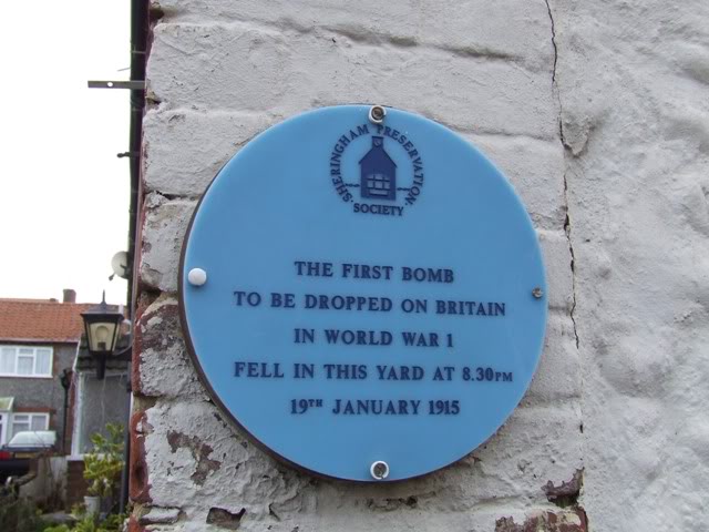
The L-4 turned northwest, and the L-3 (see below) turned south and made a bombing run over Great Yarmouth. The L-4, following the coastline, dropped two incendiary bombs on Sheringham. Today, the site of the first bomb is marked with a small "blue plaque" remembering the event. Curiously, the bomb fell through the roof of a residence and misfired. It was quickly, and bravely scooped up up by a local man and taken out and extinguished in a horse trough outside! Very brave man! The remnant of that bomb is today a part of a display at the Sheringham Museum!
And here is the site of the bombing today:
Photo credit: 7thLeicesters, https://www.tapatalk.com/groups/the_trench_line/first-zeppelin-bomb-dropped-on-england-t1946.html
As with many of the historical sites in England, it is proudly marked with a "blue plaque", commemorating the historic event:
Photo credit: 7thLeicesters, https://www.tapatalk.com/groups/the_trench_line/first-zeppelin-bomb-dropped-on-england-t1946.html
This historic site is at (Lat Lon) 52.944453 001.213111. Viewed here in Google Earth. (This is a private residence, so I would caution anyone going to the site, be respectful and leave the residents at peace):
Great Yarmouth, UK
On the night of 19-20, Jan, 1915 the Zeppelins L-3 and L-4 made a bombing run at England (see map above) intending, apparently to bomb Humberside and the docks. The L-4 turned northwest along the coast, but the L-3 turned south and made a bombing run over Great Yarmouth. The commander of the Zeppelin had no idea where he was, but dropped 10 bombs as he was notified by the crew of lights below.
The Zeppelin L-3:
Photo credit: Public Domain
Thomas Fegan in his book "The Baby Killers: German Air Raids on Britain in the First World War" writes: "The first bomb fell in Norfolk Square, a garden behind Albermarle Road; the second landed on a stable at the rear of 78 Crown Road; the third landed in St Peter's Plain where the first ever casualties of an air raid in Britain occurred."
Those two fatalities St Peter's Plain were Martha Taylor and Samuel Smith - (see their grave sites, below). The world has long forgotten them, as the world does, but the city of Greater Yarmouth has rightfully kept their memory alive.
Martha Taylor and Samuel Smith
Photo credit: Great Yarmouth Local History and Archaeological Society (GYLHAS)
Martha Taylor
The location of these first casualties is the subject of this particular remembrance. Here is a shot of the bomb-damaged home where Martha Taylor lost her life that night in January, 1915:
Photo credit: Public Domain
Another photo, taken from a slightly different position, allowed me to identify the exact location of the bombed-out home:
Photo credit: Public Domain
The distinctive Church tower in the background (the present-day Greek Orthodox Saint Spyridon Church) immediately gave-away the location since I knew the the town and the church building, easy to find, still exists. All I had to do was look for properties which would result in that perspective of the Church tower. And here is the place. (This is a private residence, so I would caution anyone going to the site, be respectful and leave the residents at peace):
Photo credit: Google Earth
From this perspective (above) you can even still see the tower of the Church in the background, upper-left.
Just above the arch of the door, barely visible behind the tree limb in this photo, is a blue plaque commemorating the historical event. (Many historical sites throughout the UK are commemorated with these blue plaques.)
Photo credit: ITV News Anglia
The location is (Lat Lon) 52.603293 001.731139. Here it is on Google Maps:
Martha Taylor was 72 years old and is buried in the Caister Old Cemetery in Caister-on-Sea, north of Great Yarmouth, UK.
Photo credit: https://www.geograph.org.uk/photo/5011925, Copyright Adrian S. Pye, Creative Commons License
The grave site is located at (Lat Lon) 52.652983 001.721797. (Just paste those two numbers into Google Maps, Google Earth, Bing Maps, or your favorite map application to see where this is.)
Samuel Smith
Samuel Smith was aged 53, a shoemaker and was the 2nd person killed by the Zeppelin bombing. He is buried at St, Nicholas Cemetery, Gt. Yarmouth.
He was killed across the street from the home of Martha Taylor in the area seen here. This is located at (Lat Lon) 52.603341 001.731231. (Just paste those two numbers into Google Maps, Google Earth, Bing Maps, or your favorite map application to see where this is):
Photo credit: Unknown. (Found on Pinterest)
Here is a photo of his grave site:
Photo credit: Unknown. (Found on Pinterest)
The grave site is located at (Lat Lon) 52.614803 001.733083. (Just paste those two numbers into Google Maps, Google Earth, Bing Maps, or your favorite map application to see where this is.)
Little Wigborough
(There is no monument at this site, but it is interesting just the same!)
During the same raid on England the night of 23-24 September, 1916, the L-33, part of a four-airship raid (see Billerycay, below), was hit by anti-aircraft fire and began to lose her hydrogen gas. Unable to return to Germany, the L-33, crippled, landed near the cottages of Little Wigborough at about 1:20 AM.
The German crew of 21 all survived, and set the zeppelin ablaze to prevent it from falling into British hands. The crew then marched together, some sources say south toward the coast, while other say they headed to Peldon, where they encountered a policeman and as they continued toward Peldon they were arrested. (Indeed, there is a record of 12 officers and special constables being awarded a specially engraved watch for their honor and bravery the night they captured the German crew.)
I have found no photos I could definitively say is the L-33. As mentioned above, there is no memorial at the crash-landing site, but since the crash site remains well-known, I am including it here. In 2016, on the centennial of the event, the local communities held a special remembrance "celebration". There is even a website dedicated to the commemoration.
As the wreckage was not completely destroyed, inspection of the remnants provided the British with significant information about the construction of Zeppelins, which was used in the design of the British R33 class airships.
The L-33 came down in a field, right near the New Hall Bungalow, which still stands today.
One of the many images of the burned-out wreck:
Photo credit: Public Domain
The site of the wreck is at (Lat Lon) 51.799284 000.872176, seen here on Google Maps. The map-tack is positioned near he spot where the control gondola landed, and the main body of the Zeppelin fuselage crossed Copt Hall Ln to the SSE. (There is no commemorative marker):
Billericay/Great Burstead
On the 23rd of September, 1916, four Zeppelins, the L-31, L-32, L-33, and L-34 made a bombing run on England. That night, on the 24th of September, the Zeppelin L-32 was intercepted and shot down over Billericay, UK. The Zeppelin crashed in flames on the Snails Hall Farm, in an area known today as South Green, east of Greens Farm Lane.
The bodies of the L-32 crew were gathered and buried at Great Burstead. In 1966, the bodies were exhumed and buried at Cannock Chase. (See, Cannock, below).
I located a single photo of the L-32:
Photo credit: Public Domain
For those interested, the downing of the L-32 is dramatized in the 1930 Howard Hughes movie "Hell's Angels". In the movie, there is a 21 minute segment depicting the bombing attack and the heroics of the UK fighter pilots. There is a brief scene where one can read "L-32" emblazoned on the side of the doomed Zeppelin as she takes on gunfire. The Zeppelin segment is filmed in an eerie blue cast to dramatize the night and clouds. The entire Zeppelin segment is on YouTube at: https://www.youtube.com/watch?v=oTAuT6ZMZXM
The L-32 crash site, 1916:
Photo credit: Public Domain
On the 100th anniversary of the crash, the Billericay Town Council unveiled a small memorial to the L-32:
Photo credit: https://www.bennettsfunerals.co.uk/billericay-centenary-commemorative-plaque-unveiling-saturday-24th-september-2016-sponsored-bennetts-funeral-directors/
The marker is along Greens Farm Lane at (Lat Lon) 51.617206 000.431944. Here is the location on Google Maps:
Cannock
North of Cannock there is a cemetery dedicated to German soldiers who lost their lives in the UK in both World Wars. At the cemetery is a grave site containing the crews of four German Zeppelins from World War I. It is the Cannock Chase German Cemetery:
Photo credit: Baz Richardson,
https://www.flickr.com/photos/bazrichardson/8233078900
The four mass graves are for the Zeppelins SL II, shot down 3 Sep,1916; L32, shot down 24 Sept,1916; L31, shot down 2 Oct,1916; and L48, shot down 17 Jun,1917.
Each of the four mass graves record the names of the German crews. The center stone reads"
"BEI IHREN KAMERADEN ZUR LETZTEN RUHE GEBETTET LIEGEN HIER DIE BESATZUNGEN VON VIER IM ERSTEN WELTKRIEG ÜBER ENGLAND ABGESCHOSSENEN ZEPPELINEN VON DEN URSCHPRNÜGLICHEN BESTATTENUNGSORTEN POTTERS BAR GREAT BURSTEAD UND THEBERTON WEREDEN DIE GEFALLENEN HIERER ÜBERFÜHRT. DIE TOTEN JADER BESATZUNG SIND IN EINER GRABSTÄTTE IN SARKOPHAGEN BEIGESETZT".
"SIDE BY SIDE WITH THEIR COMRADES, THE CREWS OF FOUR ZEPPELINS SHOT DOWN OVER ENGLAND DURING THE FIRST WORLD WAR HERE FOUND THEIR ETERNAL RESTING PLACE. THE FALLEN WERE BROUGHT HERE FROM THEIR ORIGINAL BURIAL PLACES AT POTTERS BAR, GREAT BURSTEAD AND THEBERTON. THE MEMBERS OF EACH CREW ARE BURIED IN CASKETS IN ONE GRAVE".
The coordinates are (Lat Lon) 52.739476 -002.021807, located here in Google Maps:
Pembroke England: Carew Cheriton Airfield, former Royal Navy Airship Station
At the Carew Cheriton Airfield Museum, near Pembroke, is a small monument dedicated to those who worked at the airfield from 1915-1918 (WW I) and 1939-1945 (WW II). Surrounding the monument are cement blocks which were airship mooring weights.
Photo credit: Gary Ball
Photo credit: Gary Ball
The museum is located at (Lat Lon) 51.692018 -004.818416, Carew Cheriton, near Pembroke, UK.
Cardiff England - The Willows clock Tower:
Ernest T. Willows is considered "The Father of British Airships". Though there is no major monument to him and his work, there is this fine clock in Cardiff, the home of the majority of his early work.
The Willows No. 4. Photo credit: Public domain
Willows Clock Tower, Cardiff. Photo credit: Waymarking, Public domain
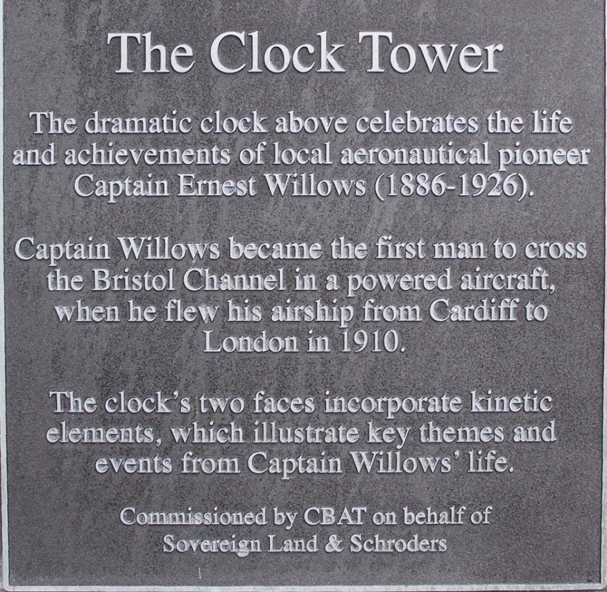
At sidewalk level, under the tower is plaque explaining the clock:
raescardiff.innerdown.co.uk (site has disappeared)
The location of the clock is at (Lat Lon) 51.463298 -003.164916 in Cardiff.
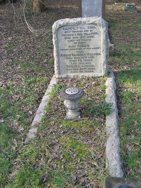
Cardiff England - Willows Gravesite:
Ernest T. Willows is buried at the Cathays Cemetery in Cardiff. The grave is approximately here, (Lat Lon) 51.501963 -003.180537. This is an estimate based on the Cathays Cemetery Plot map provided to me by Mr. John Farnhill of the Friends of Cathays Cemetery FaceBook Group. The Willow's grave is in plot I-311 and this Lat-Lon is probably within 3-4 meters (9-12 feet).
Ernest Willows Grave. Photo credit: Public domain
The cemetery location in Cardiff is here in Google maps:
Cardiff England - "The Ernest Willows" Pub:
In Cardiff, about a mile from where Ernest Willows was born, is a Wetherspoon pub named "The Ernest Willows" which recognizes E.T. Willows and his accomplishments.
Photo credit: https://cathaysonline.files.wordpress.com/2011/11/img_0202.jpg
This is the nice photo and narrative found at the pub:
Photo credit: https://www.jdwetherspoon.com/pub-histories/wales/cardiff/the-ernest-willows-cardiff
The inscription reads: "J.D. Wetherspoon pub is named after ‘the pioneer of the air’, whose birthplace is nearby Newport Road is now part of Cardiff University. He is also commemorated in the name of Willows High School.
Willows' obsession with flying was encouraged by his father, who financed his experiments. Early airships depended on the wind, but Willows’ machine was a dirigible – this is, steered by powered propellers.
In 1905, aged 19, Ernest piloted an airship of his own design over his workshop on East Moors. In 1910, he won a £50 prize for being the first to fly over Cardiff, landing near the city Hall. He repeated the feat three days later, before a crowd of some 40,000 people.
The same year, he flew from Cardiff to London, and in a new ship, the City of Cardiff, across the Channel to Paris. However, these exhibitions failed to attract financial backing, and he joined Airships Limited, in London. There he developed ideas used in the production of “Blimps”, tethered balloons used to protect London against air raids during World War I.
After war service in the Royal Flying Corps, Willows produced kite balloons for the War Department at the old Roller Skating Rink in Westgate Street. He was killed in a balloon accident near Bedford in 1926."
The pub is located at 2–12 City Road, Roath, Cardiff, CF24 3DL, at (LAT LON) 51.485678 -003.165636. Here is the location in Google maps:

