DeMystifying the "Marfa Lights"
- You are here: A short description of the "Marfa Lights"
- Details of the "Springs Lights" discovery
- "Observations" page: counter-explanations to Marfa Lights theories & observations
- Return to the "De-Mystifying "main page
- Return to the Votum Separatum home page
A short description of the "Marfa Lights"
From the "Skeptics Dictionary" (skepdic.com): "The Marfa lights are lights which are visible from a viewing area about 10 miles east of the town of Marfa, Texas. They are the main tourist attraction in the area. The lights are said to appear to bounce around in the sky, vanish and re-appear, and thus are considered a mystery by some. To others, the lights are not a mystery. They are ghosts or swamp gas or radioactive bursts or ball lightning or navigational lights for space aliens. Skeptics who view the lights with strong binoculars claim that they are nothing more than the headlights and tail-lights of cars in the Chinati Mountains on U.S. highway 67. "
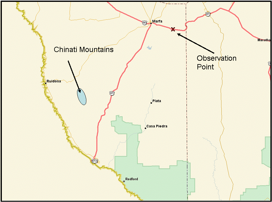
The Marfa Lights are said to be visible at sunset any time of year, from a location about 8 miles East of Marfa, TX, on Highway 90. The general area is shown in Fig 6. (Click on the figure for a larger version). Marfa is at the upper center, and is located about 143 miles SW of Odessa, TX. Forty-two miles toward the SW from Marfa is the Chinati Mountains (marked roughly by the blue oval on Fig 6).
One of the interesting features of the geography of Marfa, Texas and the Chinati Mountains is that it is an incredibly flat area, barely sloping upward from the observation point outside Marfa (at 4900 feet elevation) toward Chinati Peak at 6550 feet elevation; a change of only 1650 feet in a distance of 42 miles! And the land is so flat, that the entire span (between the observer and Chinati Peak) is nearly at the same elevation as the observation point all the way to within 1.2 miles of Chinati Peak when the slope finally becomes significantly steeper and climbs to the peak! In fact, the area is called "Mitchell Flats."
(A word about describing this area as "flat". What I am saying is that between the observation point at Marfa, TX, and the Chinati mountains, the overall elevation only changes by 1500 feet over 42 miles span! This is an average change of only about 35 feet elevation per mile! Certainly, locally, one could stand anywhere within this great span and not draw the conclusion that the span is "incredibly flat" because locally you might see large variations in elevation. Nevertheless, from the observation site, the land only gradually climbs by 1500 feet 42 miles away.)
Between Marfa and the Chinati Mountains, Highway 67 runs south-southwest, generally along a bearing (azimuth) of 209o from Marfa to Presidio, TX. The highest spot on Highway 67 is right at 5300 feet and happens to be at a spot almost exactly midway between the observation point outside of Marfa and Chinati Peak. This highest point on the highway is between the spot marked "B" and "C" in Fig 7. It is, of course, important for the observer to be able to see the lights without something in between, obstructing the view. Referring to Figure 7, the height of the land between the observation point, "F", and point "B" varies only slightly and is always below the observer. As one's line of site reaches the highway (at point B), the land rises to an elevation of 5000 feet - just 100 feet higher than point "F". Point "A" is 4550 feet elevation - 350 feet below point "F" and the highway span between B and A is a relatively constant slope downward toward "A", never going up and down. The distances between these points is vast compared to the small elevation differences and the changes in elevation are so insignificant, that one could argue the land is essentially flat. Notice that between A & F the distance is 13.8 miles, between B & F the distance is 21.8 miles, and the distance to Chinati Peak from F is 42 miles.

All of the above analysis is simply to assess the situation and allow the following discussion about the visibility of car lights from Highway 67: From the observation point (F in Figure 7), based on the topography described in the paragraph above, it is clear that auto headlights should be easy to see when the vehicles are NE bound and are on the section of highway between points B and A. There may be regions where the line of sight from F to that section of Highway 67 is obstructed by the ground but I did not study the topography to that detail. In the case of Highway 67, the land area "D" in Figure 7, is higher than the part of Highway 67 between points B & C and consequently one cannot observe cars on that section of the Highway from the observation point even though the highway itself is at its highest elevation along that section. It seems clear, however that the section of Highway 67 between points B & C is definitely obstructed from view by the "rise" in the topography to the East of the highway which I've illustrated by the crude red blob in Figure 7, marked "D". This area is around 5000 feet, well above the level of the highway from "B" on South. Even if the obstruction from the "rise" (D) were not there, the highway, from "C" on South, is, once again, at the same elevation as the observation point and is descending in elevation from that point, toward Presidio and would definitely not be visible from the observation point, "F".
All this serves to indicate that an observer at point "F" should be able to see car headlights on the highway while looking at a true azimuth (not magnetic) of 230o to 240o from the observation point. Chinati Peak will be observed along a true azimuth of 238o giving the distinct impression the lights on Highway 67 are "below" the peak. All this can be discerned from simply looking at topographical maps of the area!

Figure 8, from astronomycafe.net/.../marfa10.jpg, is one of the rare photos claimed to be of the "Marfa Lights". There is no documentation to describe this photo, so all we can do is make some assumptions about what it shows. The photo appears to have been taken with a lens equivalent to a 50mm lens of a 35mm camera, based on the span of the horizon visible in the photo. I assume the shot was taken from the established viewing site, about 8 miles East of Marfa on Highway 90, the same spot I have marked as "F" in Fig 7 as this is the location of the "official" viewing site set up by the state of Texas. Thus, Chinati Peak is being viewed at 238o true azimuth, and the far left light is likely about 230o because the light has (apparently) just appeared from the edge of the "rise" (see "D" in Fig 7.) The other two lights appearing to the right of the first are slightly lower - this is exactly as the highway topography follows, described above. The left-most light then would be about 22 miles away (assuming it has just appeared from around the "rise"), and the other two lights are likely about 20 and 17-18 miles respectively based on the fact that the lights appear to the left of the peak and have not yet reached point "A" in Fig 7, which would be 13.8 miles away and would appear just to the right of the peak. Note also that the right-most light appears brighter than the other two, again, exactly as one would expect since it is somewhat closer to the camera (and/or turned more toward the camera).

In Figure 9 I've marked on the photo what I attempted to describe in the text. What I described as a "rise" in the topography and marked as "D"in Fig 7, I believe is what is visible in the photo to the left of the lights. The lights themselves appear exactly as I expected they would based on an analysis of the area on a topographic map.

And in Fig 10, from astronomycafe.net/.../marfa16.jpg, the position of the lights, Chinati Peak, and the "rise" are, again, exactly as expected assuming the photo was taken from the observation point. Notice the location of the telephone poles between Fig 9 and Fig 10 - they are identical, indicating the two photos were taken from the very same spot or very close to the same spot. (This shot shows evidence that it was a "time exposure". The "glow" on the horizon, far left, the "broadening" of the lights which moved during the exposure, and the long strip of light in the lower third of the photo are all indications of a time exposure. The long strip was likely created when someone carrying a flashlight walked past the camera unaware the exposure was being made. The photo also shows signs of underexposure, and may be a 35mm slide, or a print scanned into a computer to make the digital image. It is also likely that the camera aperture was stopped down significantly since the streak left by the (presumed) flashlight is comparatively faint. The white specs in the sky which at first one would assume to be stars appear more likely to be dirt or specks on the slide. I've seen many photos of scenes with stars present, and these specks do not look like stars.)

Browsing web sites describing "Marfa Lights"one comes across an occasional comment that the lights are also seen at locations away from Highway 67 "where no highway exists." Figure 11 is such an example from www.scienceplace.org/science/marfa.shtml, unfortunately no longer available.
Again, no details were found to describe the photo - from where it was taken, with what lens, time of day, direction, nothing. The pole, visible in the foreground, by itself does not provide enough information, nor does anything on the horizon give any clues. One can say, that since this shot does not show the "rise" or Chinati Peak, that the lights are not near the section of Highway 67. I can only assume that this shot was from the Marfa area, and looking generally to the South. But, upon close examination of topographical maps of the area, you will find the entire span of land between the observation point and the "rise", and indeed, all the way to the Chinati Mountains, is littered with trails, paths, and dirt roads. In other words, there are countless locations where people can be, with their cars, and their headlights. (I find it interesting that I found no other web site about the "Marfa Lights" which reveal this fact - as of the original date of this article, Dec 2004.) Therefore, even though the lights in the photo above are not on Highway 67, there is certainly no reason to believe the lights are anything but manmade lights, including headlights!
And a note to any and all "Marfa Lights" aficionados: Photos like the ones above are useless without complete details. If providing evidence of "Marfa Lights" please include, in addition to the description of the observed lights, the date and time of the photo, exact location of the camera (latitude and longitude), exact azimuth the camera is pointed, whether or not the photo is from a still camera or a frame extracted from a video, whether or not the camera was a standard film camera or a digital camera, and if film (anyone still use film?), what film was used and the exposure time and F-stop, along with the details of the lens - aperture and focal length. Include a description of the weather conditions at the time. Include also whether or not a tripod was used and a description of any identifiable features in the photograph, for example, if Chinati Peak is present, point it out.
- Details of the "Springs Lights" discovery
- "Observations" page: counter-explanations to Marfa Lights theories & observations
- Return to the "De-Mystifying "main page
- Return to the Votum Separatum home page
Page copyright, 2004-2015 William J. Welker, Colorado Springs, Colorado
E-Mail: 
Page last updated Dec 18, 2015
Site hosted by: WELWEB.ORG