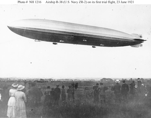
The ZR-2 started life as the R-38, a British-built airship, originally intended to be part of the airship fleet of Great Britain capable of carrying armament and week-long coastal patrols. A contract was awarded for the R-38 in 1918 to the UK firm, Short Brothers, along with orders for the R-39, R-40, and R-41. However, with WW I over, and military cutbacks a reality, the order for the R-39, 40, and 41 was cancelled. The R-38, was also to be cancelled, but a deal was brokered with the US to purchase the R-38 as the US was interested in a rigid airship program of its own. The US was already pursuing construction of the ZR-1, USS Shenandoah, which would be built at Lakehurst, NJ, so the R-38 was scheduled to become the ZR-2.
Construction
The R-38 was built at Cardington England in 1919 and delivered to the Royal Naval Air Service (RNAS) station at Howden in June 1921 to be modified for US service. She was 695 feet long, and 85.5 feet in diameter with a top speed of 71 mph. Designed as a war-bird, she could carry 24 machine guns and 12 bombs. Additionally, a platform on the top of the hull could carry a heavy machine gun called a "one pounder", a 37mm autocanon.
Operations
After delivery to Howden, the R-38 returned to Cardington for modifications, then back to Howden for air worthiness trials. In August, 1921, she made her 4th and final flight intending to be moored at RNAS Pulham. She never made it.
Demise
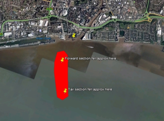
On 24 August, 1921, the R-38/ZR-2 was on the way to RNAS Pulham, when the crew entered into some low-altitude rudder tests to simulate rough weather expected on Atlantic crossings. The crew ended up over-stressing the frame of the R-38/ZR-2, and the aluminum girders buckled. The ship folded and broke in two, the forward portion burst into flames, and both sections crashed in the Humber River, just off the Victoria Pier at Hull. There were hundreds of witnesses, and a rapid response to attempt rescue. Unfortunately forty-four of the 49 crew died.
Ignominious End
The wreckage of the R-38/ZR-2 was dragged from the Humber River, and after an investigation and inquiry into the cause of the crash, the remnants were dismantled and presumably sold for scrap. A Court of Inquiry in October that same year established the blame as structural failure.
Sites of Interest
Royal Naval Air Station (RNAS) Howden:
RNAS Howden was a large airship facility a few miles north of Howden, Yorkshire, England during WW I.
Photo credit: Public Domain.
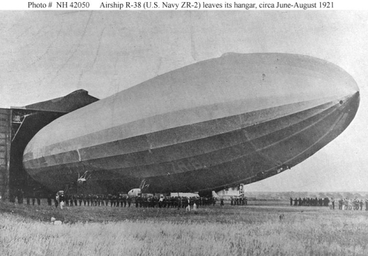
This image shows the R-38/ZR-2 emerging from Hangar 1 at Howden, sometime in the summer of 1921. Other photos confirm this is Hangar 1 and not Hangar 2 which was not only double-wide, but was two double-wide buildings joined as one. There is nothing particularly identifiable in this photo except for the hangar, but the site certainly begs to be found! It took a bit of sleuthing, but I eventually found where RNAS Howden once stood. The station is long gone, having closed in 1930 after the demised of the R-101. Over time, everything at the site was demolished. Still, finding the site and determining the location where the R-38/ZR-2 was operated led to some interesting findings.
And here is the location of the RNAS Howden in Google Maps:
The map tack (above) is at (Lat Lon) 53.786117 -000.864686. The original expanse of the Howden Station encompassed part of what is now a golf course in this image. I had located the positions of the No 1 and No 2 hangars and provided them here in a previous posting of this page. I was close! But a comment from a visitor to this page, "Greg", made me dig a bit deeper and I found a terrific source of detailed information from the Airfield Research Group publication "RN Air Station Howden, An Assessment of its Buildings". It contains a site plan which I was able to overlay on Google Earth, to visually see almost exactly where not only the two great hangars were located, but many other airfield buildings as well! In the image reproduced below, hover your mouse on the image and it will overlay the old airfield layout. (I am not a cartographer, and I did not spend time deskewing or aligning Google Earth map distortions to the overlay, yet still the alignment of roads and remaining artifacts is remarkable!)
(Click or press the blue bar in the next image and slide the bar left-to-right to see where the main Howden Airship site was located on the present day area:)
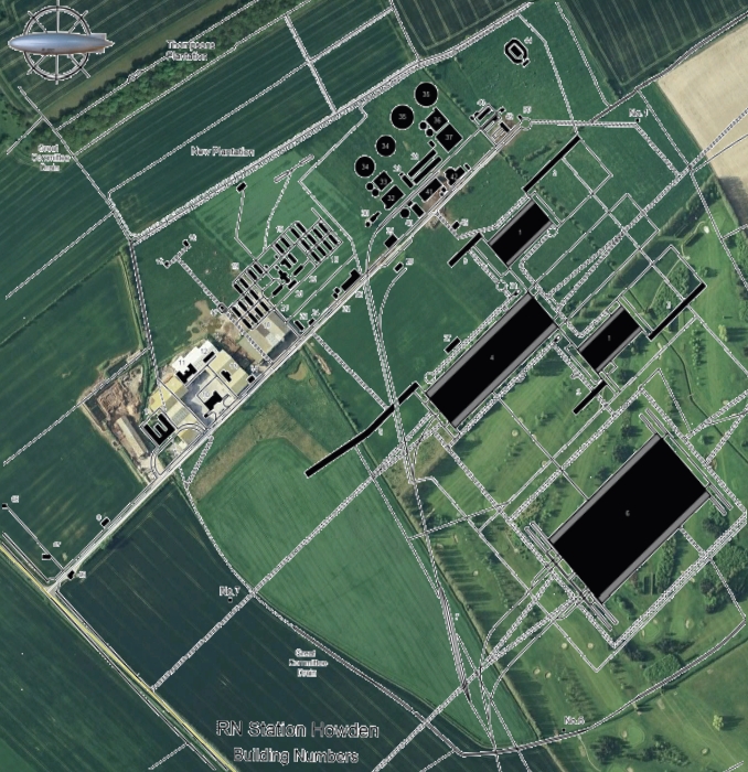
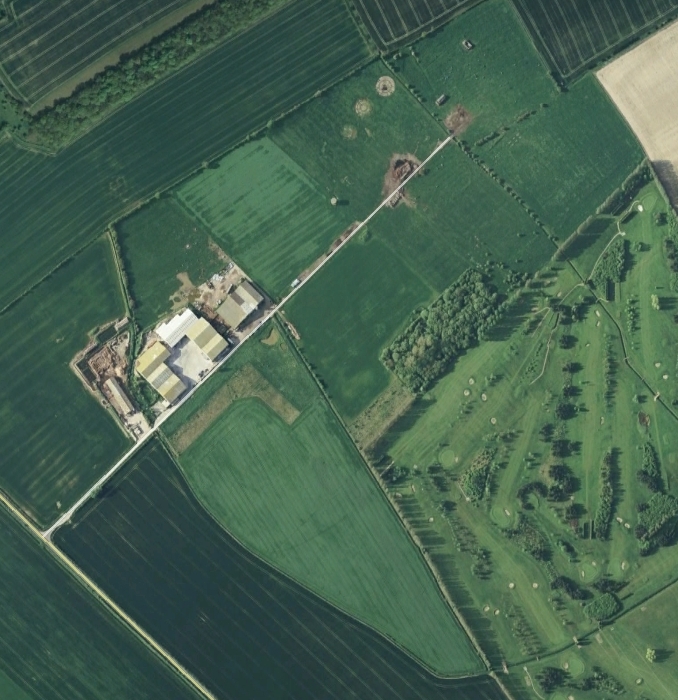
Photo credit: Google Earth; Overlay: Airfield Research Group.
The cluster of trees seen to the right of center in the image above, without the overlay of the Howden site, measures out to pretty much the exact dimensions of the Shed No 1 at Howden which was 700 feet long, and 150 feet wide. Remarkably, the location of the dual Shed, No 2, is immediately revealed when the overlay is shown (mouseover the image). It is here the R-38/ZR-2 would have been hangared! One can also see the location of the hydrogen plant - the 4 black circles in the upper-center of the overlay - and the remnants, the cement pads still present today.
Hull Crash Site:
The records I found say the R-38/ZR-2 crashed "right off Victoria Pier in the Humber River at Hull". If so, then this next graphic is a guestimate of where that might have been.
Photo credit: Google Earth.
I've identified Victoria Pier as originally at (Lat Lon) 53.737935 -000.334063, where the map tack is located in the Google map below. So I've located the red area of teh crash site, above,as my best estimate of where the R38/ZR-2 came down that fateful day in August, 1921. I drew this location from "ICARUS over the Humber", by T.W. Jamison, Lampada Press, 1994.
Memorial
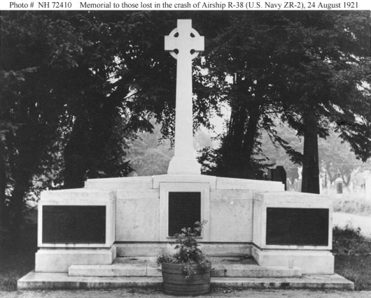
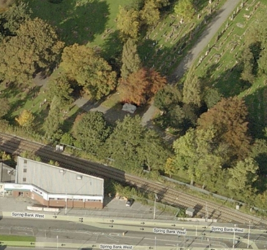
And finally, this was an exciting find. While researching the R-38/ZR-2, I discovered the memorial to the Airship Crew, which is located in Hull. The Wikipedia article on the airship, shows a picture of the memorial, but does not provide anywhere enough information to identify where it is located! Well, to make a long story short, I first found a web page which identified the Street on which the cemetery is located, and then I found the name of the cemetery. With these two pieces of information, I was able to "spot" the memorial in a map view in Bing Maps!
Photo credit: US Navy.
http://www.history.navy.mil/photos/images/h72000/h72410c.htm.
This image, above, of the memorial to the R-38, was dedicated in 1924.
Photo credit: Bing Maps
In this Bing Maps image, you can clearly see the memorial! It is located at (Lat Lon) 53.751280 -000.376309. Here is the location in Google maps:
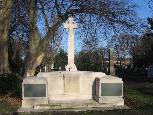
And finally, here is a photo of the memorial taken in Jan, 2012 by "Keith D", but placed on Wikipedia in the public domain. Thank you Keith D!
Photo credit: Wikipedia, Keith D.

