USS Shenandoah
The US gained interest in rigid airships due to their successful use by Germany in WW I. Both the US and Great Britain studied captured German Zeppelins during the Great War gleaning much design information, and the Shenandoah's design was based on the German LZ-96 which had been built as a bomber in 1917, but was captured by the French on October 20, that same year.

Photo credit: US Navy
This Navy photo above is the mast at San Diego, California. I identified the site of this mast by locating a 1925 map of the military facility. See below.
Construction
The Shenandoah was assembled in Hangar 1 at Lakehurst, NJ. Lakehurst was already established as a Navy Lighter-than-Air facility. She was completed in 1924 and commissioned "ZR-1", "Zeppelin, Rigid #1". She was 680 feet long, almost 79 feet in diameter, and stood 93 feet above the ground. She was designed to use helium rather than hydrogen for obvious safety reasons. (In fact, after the crash of the Roma in 1922, the US Congress mandated that US airships use helium instead of hydrogen). To conserve the scarce and expensive helium, rather than venting the precious helium, condensers were installed to capture engine exhaust to recover water vapor to compensate some for weight loss due to the consumption of fuel. She was commissioned on October 10, 1923.
Operations
The Shenandoah's capabilities were tested from September, 1923, through the summer of 1924. On January 16, 1924 she suffered an accident when, while moored at Lakehurst, a gale ripped the covering on her upper tail fin, causing her to roll and tear her nose away from the mast. She suffered significant damage but was saved by the test crew on board at the time. After repairs, in August, 1924, the Shenandoah took part in tactical exercises and mooring experiments with ships. In October, 1924, she participated in exercises cross-country to practice mooring operations with newly installed mooring masts in several locations. This exercise took the Shenandoah from Lakehurst to California and back to Washington in the first-ever crossing of the USA by a rigid airship.
Demise
On September 2, 1925, the USS Shenandoah began a good-will tour of the US Midwest, to include flyovers of several cities, and state fairs. On September 3rd, she encountered thunderstorms and was caught in an updraft which quickly took her above her pressure limits. She was torn apart in the turbulence, and crashed near Caldwell Ohio. Fourteen of her crew of 53 died, including her commander, Zachary Lansdowne. The record shows that Commander Lansdowne fought for cancellation of the publicity tour due to the high probability of thunderstorms, but was overruled by senior leadership. This incident caused Colonel Billy Mitchell to criticize senior military leadership, which, in turn, lead to his courts marshal ending his Army career. (If this does not sound familiar, look up the Space Shuttle Challenger disaster of 1986.)
Ignominious End
Since the crash of the USS Shenandoah was on land, the crash sites (there were 3) drew thousands of curiosity seekers. People being people, sadly, they turned into looters and anything they could carry way, they did so. This resulted in the loss of much of the Shenandoah's outer fabric, her logbooks, and many parts such as instruments, and controls disappearing into private homes.
Sites of Interest
Index:
Lakehurst, NJ * Ft Worth, TX * St. Louis, MO * Scott Air Force Base, IL * San Diego, CA * Long Beach, CA * Crash Sites & Memorials *
Lakehurst:
I include this first photo of the USS Shenandoah at Lakehurst, as she is being removed from Hangar 1 on September 4th, 1923, not because it is hard to find the location, as it is easy to still locate Hangar 1. I include this photo because it is both beautiful, and when compared to a similar shot of the Hindenburg in the same hangar, one gets a feeling of the enormity of the Hindenburg - and yet, the Shenandoah was a giant all her own!

Photo credit: Abandoned and Little Known Airfields.
http://www.airfields-freeman.com/NJ/Airfields_NJ_E.htm
This shot, above is at (Lat Lon) 40.029381 -074.3178. (Click here to View in Google Maps).
For comparison, take a look at this photo of the Hindenburg in the same hangar:
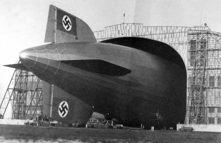
Photo credits: National Archives.
http://www.airfields-freeman.com/NJ/Airfields_NJ_E.htm
All I can say is WOW! The Shenandoah fills up barely a 5th of the opening in the hangar, while the Hindenburg fills up well over half! Oh my! These great airships must have been absolutely something to see! Nothing in our times, not even the US Saturn V rocket, the US Space Shuttle, or the Russian Nova rocket was ANYTHING like the Great Airships!
Cathedral of the Air:
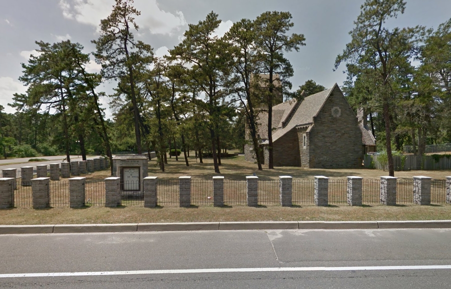
Photo credits: Google Street View.
The shot, above is at (Lat Lon) 40.017873 -074.310421. (Click here to View in Google Maps).
The Cathedral of the Air was built in 1932 by the American Legion to serve military personnel of the surrounding military facilities. Suprisingly, little information is found on-line about its history - even the Wikipedia article about it is only one short paragraph! Within its walls, both the USS Shenandoah and the USS Akron are commemorated with bronze plaques.
Here is the plaque commemorating the USS Shenandoah. Note the it was dedicated in 1926, just one year after the fateful disaster. I could find absolutely no information on where this plaque was originally placed. Dedicated in 1926, at least 6 years before the Cathedral of the Air was completed, this plaque certainly was dedicated and displayed somewhere else!
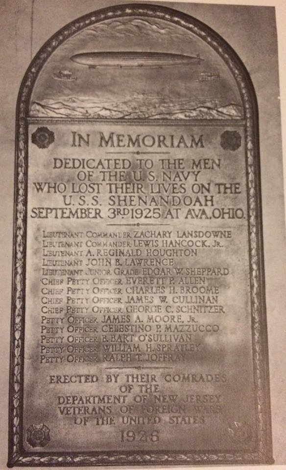
Photo credits: Rick Zitarosa.
It's a fine tribute to the crew of the Shenandoah, but it is sad that it has fallen into such obscurity. I've been researching airships for at least 15 years and did not become aware of the existence of this Shenandoah plaque till I saw a post on the AIRSHIPS, DIRIGIBLE, AND ZEPPELINS FaceBook page, https://www.facebook.com/groups/airshipblimpzeppelin/, in 2016.
Ft Worth, Texas; Helium Processing Plant:
This next photo haunted me for a long time because I know it is the Shenandoah, and I know was shot from Ft Worth, TX, and I know the date. It was the 9th of Oct, 1924, taken some time after 9:46 AM. Despite all this information, I did not know a key and desired piece! The location of the Mast! (A very fine story of the Shenandoah's cross-country trip in 1924 is found in the Jan, 1925 issue of National Geographic. It describes how the Shenandoah arrived at Ft Worth at 8:30 PM on October 8th, and departed at 9:46 AM on October 9th.)
Still, all I knew was that the mooring was at or near the Helium plant in Ft Worth. Yet, this is a nice picture from that spot, and it would be nice to know exactly where it was! I'm probably the only person on earth who cares and simply wants to know where this mast was, but how many there are doesn't matter. Here is the photo:

Photo credit: http://www.b-36peacemakermuseum.org/Airship/tabid/808/Default.aspx
(The same photo also appears in the Jan, 1925 National Geographic, page 12.)
Well, I found it! Here is where it was:

Photo credits: Google Earth.
In this shot, above, the Mast map-tack is at (Lat Lon) 32.828463 -097.346317. I also placed a map-tack at the location of the remnants of the Helium Plant. Here is a map with the position of the Ft Worth Mooring Mast marked in Google Maps:
How do I know this? I'm glad you asked! I found a discussion of the Helium Plant location at the "Fort Worth Forum", with a link to some very nice photos of the Helium plant remnants, and though no one in the forum knew the location of the mast, someone did post that the Helium plant had been near the intersection of Meacham Blvd, and Blue Mound Road! Armed with this new information, I quickly found the location of the plant in Google Earth (See map-tack above). Since the mast site was not known, and the area showed no signs of a mast at the Meacham International Airport, about a mile to the west of the helium plant, I decided to search for a map from the period. I struck pay dirt! I found a terrific map of the Ft Worth area at the University of Texas Libraries, a fairly detailed and high resolution map, too large to reproduce here. But here, below, is a section of the map, and what did I find? A site clearly marked "UNITED STATES HELIUM PRODUCTION PLANT", and a second site marked "UNITED STATES DIRIGIBLE MOORING MAST"!
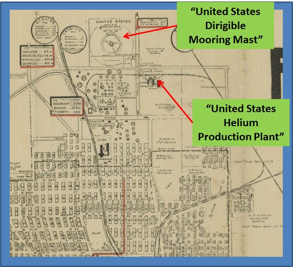
Photo credits: University of Texas Libraries.
So my next step was to overlay the map on Google Earth. After lining up the streets, many of which are the same as they were in 1925, I was able to "see" where the mast used to stand! Here is my overlay. click/touch the blue slider and move it left-right to alternate the view with and without the overlay:
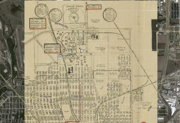
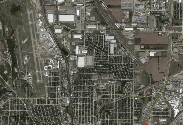
Photo credits: Google Earth & Univ of TX Libraries (overlay).
Not having cartographic tools, I think the alignment is pretty good. In the lower third of the Google Earth image, the criss-cross of roads match very well, and the road where the rail spur which ran south of what is Meacham Blvd today, lines up well with the 1925 map. Unfortunately, "Blue Mound Road" does not line up with the road immediately to the West of the Helium Plant, but the 1925 map shows "Decatur" was also called "Blue Mound Road", and since the area became very industrial over the last 88 years, I suspect much road redesign and relocation over the years. Nevertheless, I think the location of the site of the Ft Worth Mooring Mast is fairly "sound". It might be a few feet in one direction or another, but I consider the location now "known"! Mystery solved!
St Louis:
I spent a LOT of time on this next photo and finally identified it! It is the USS Shenandoah over St Louis, Missouri, which dates it to on or about 2 October, 1923, just one month after her first flight, and even before her "christening" on 10 October. I was misled for a long time trying to identify this photo by the Hill-Behan Lumber Co which is visible in the photo along the left side, about 1/3 the way down. It took me hours of study to finally realize the text in the image was "Hill Behan Lumber Co.", the words "Lumber Co." being far more legible than "Hill Behan"! This made me think this photo was from 1924 during the cross-country trip the Shenandoah made when she traveled across the southern US - and the Hill Behan Lumber Co had stores in Missouri, Mississippi, Illinois, and Louisiana.
The Hill Behan Lumber Co resulted in a wild goose chase because the January, 1925 issue of the National Geographic magazine article provided me with the major cities the Shenandoah passed, and they Spartanburg, S C; Atlanta and Carrollton, Ga.; Birmingham, Ala.; Columbus and Greenville, Miss.; Bastrop and Shreveport, La.; and then to Dallas and Fort Worth. I thought I struck gold! All I had to do was match the roads in the photo to the roads in the cities she passed over in Mississippi and Louisiana, and I would have it! But....
For days I looked over the map for nearly every large city along the flight path and found...NOTHING! I was so discouraged. Then, another breakthrough. Though I had seen it before, for some reason, it did not "click" that this could be in the St Louis area, but I Googled "USS Shenandoah St Louis", and the wiki page (which I had seen many times before) came up - and there in front of me was a small photo of the Shenandoah moored at....ST LOUIS! So I resumed my road search and quickly found the key indicators! There it was before me! She was near the Bethany Cemetery (one of the indicators in the photo) and over what is today near Dr. Martin Luther King Rd, and Keinlen St or Hodiamont Ave. in St. Louis! So, here is the photo:
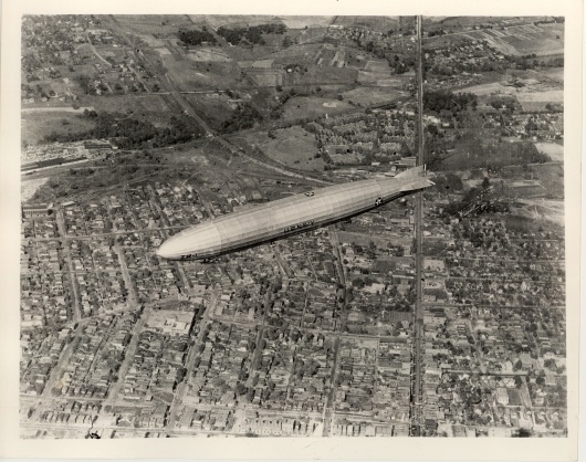
Photo credit: Urbana School District 116, Urbana, Illinois
Full size photo at usd116.org
And in this next shot, the perspective is set to approximate the same perspective of the 1923 USS Shenandoah photo but with the image of the Shenandoah overlaid. It's a little hard to tell, but the streets line up perfectly, except where 90 years of change has taken place! The Bethany Cemetery matches well, and some, but very few, structures line up. (It's amazing how few structures are original, considering the 90 year span between the original 1923 photo and this graphic from 2012!

Photo credits: Google Earth.
And here is the location on the map. The map-tack is at (Lat Lon) 38.673797 -90.286592.

Photo credits: Google Earth.
Here is a direct link to google maps:
Photo credits: Google Earth.
This next photo, also from the St Louis overflight, I recently added to my growing list of identified locations! I always knew the photo was from the same overfight of St. Louis as the previous photo (above), but I had long set it aside not sure I could locate its site on a map. But I spent some more time on it, and my effort paid off! Here is the second photo:

Photo credit: Urbana School District 116, Urbana, Illinois
Full size photo at usd116.org
I was first able identify the large warehouse buildings behind and to the right of the ZR-1's tail, then the "mansion" in the middle of the right side of the photograph. Once those were identified, I was able to match more buildings in the area under the ZR-1, positively confirming I had found the location this photo was taken. Here is the site as seen in Google Earth:

Photo credit: Google Earth
I placed the map tack in the photo above at (Lat Lon) 38.669219 -090.279231 by guessing the point on the ground over which the ZR-1 is at the moment the photo was taken. May not be exact, but it is close.
(Click here to View in Google Maps).
Since you don't have the benefit of knowing which buildings in this Google Earth image match the 1923 photo of the Shenandoah, here is a direct comparison:

And a close-up of the two key identifying buildings:

There's more! I was stunned to see only ONE building still existing in the street which appears under the nose of the Shenandoah in the photo. That street is Theodosia, and using Google Earth "Street View", I captured a photo of that one remaining building. Here it is:
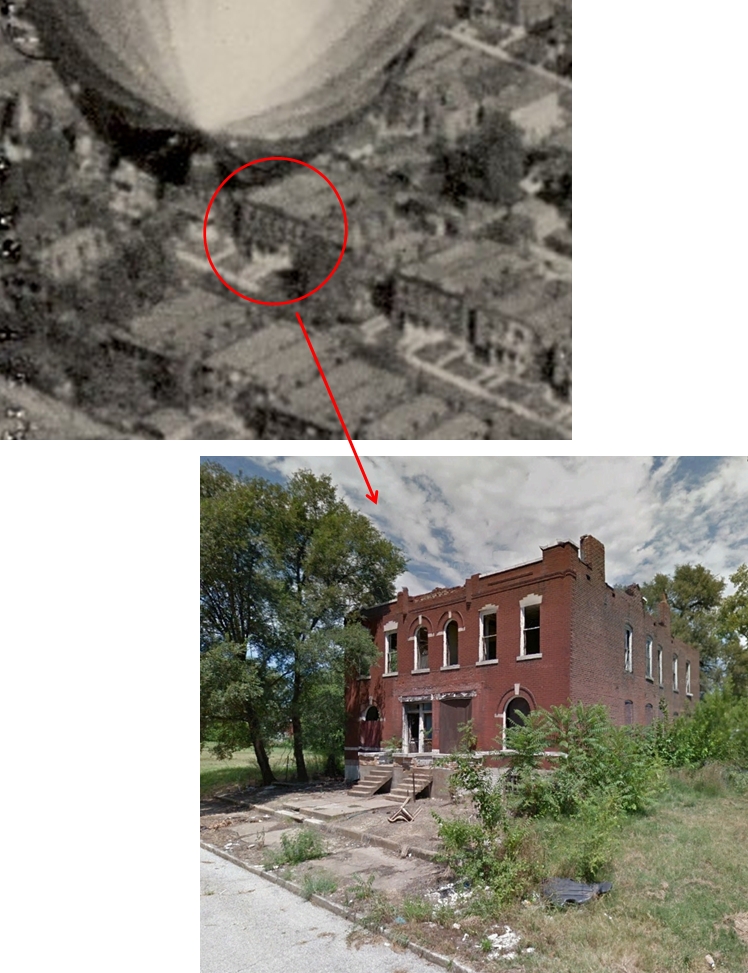
Photo credit: Google Earth
And one more road stood out. That is what is today called Dr. Martin Luther King Drive. I matched 5815 Martin Luther King Dr with the 1923 photo:
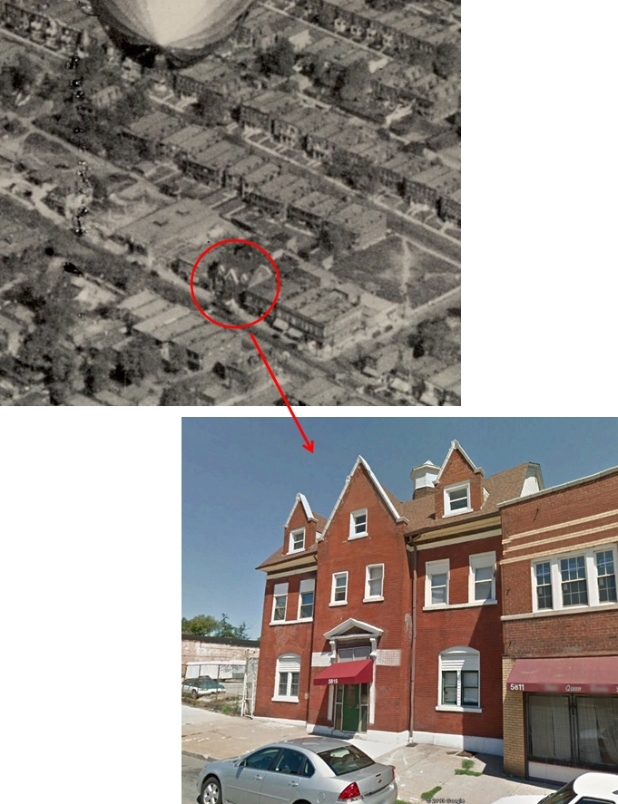
Photo credit: Google Earth
Scott Air Force Base, Illinois
Mystery of Scott Air Force Base, Illinois
Scott Field (re-designated "Scott Air Force Base" in 1948), near St. Louis, was built as an aviation training field during World War I. Training operations began there in late 1917. Scott Field survived the end of WWI, and became a "Lighter-than-air (LTA)" base in 1921. They had big plans for LTA! A giant airship hanger was immediately built and was completed in January 1923. Scott's hanger was second in size only to the great hangar at Lakehurst, NJ, and was 810 feet long, about 200 feet wide, and 185 feet tall! She could easily hold an airship like the Shenandoah, which was 680 feet long and stood a little over 93 feet high from the ground.
Shenandoah was on test flights in September & October of 1923, the purpose of which was for airworthiness, and handling in as much weather as they could encounter. Since Scott Field was clearly to be a "hub" of airship operations, it made quite good sense that the Shenandoah would land there for handling operations tests, and perhaps, though I could find no evidence of it, hangaring tests in Scott's giant hangar. But did she land at Scott field?
There is a terrific photograph of the Shenandoah described as landing at Scott Field, which I will reproduce here and link to the original since there is a copyright on it. It shows the Shenandoah coming in steeply on Oct 2, 1923. The original photo was a 4x5 glass plate, and the digital scan is not particularly good, plus they scanned the image backward. This is why I have posted a copy of the image here, but corrected left-to-right.
Photo credit: University of Missouri, St. Louis Mercantile Library.
The original photo is found here: St. Louis Globe Democrat Collection
This is such a great photo, I simply had to try to locate where it was taken as best I could. But I couldn't.
Associated with this terrific photo is the caption:
Description: Scott Field, IL - Full right side view from ground of United States dirigible ZR-1 in flight making approach for mooring. Craft is approaching ground at very steep angle. Many men are faintly visible on ground ahead in far distance beneath craft to grab mooring lines.
Subject: Scott Air Force Base (Ill.)
Subject: Aeronautics - Missouri - Saint Louis
Title: Aviation - Dirigible, Scott Field, IL
That clearly suggests that the Shenandoah landed at Scott Field.
Certain that the Shenandoah landed at Scott Field, the original posting of this page included it as fact. But in October, 2019, I received a contact from Mark Wilderman, the Air Force Historian at Scott AFB, asking me if I had solid information that the Shenandoah landed at Scott Field as he had found no evidence that it happened.
So I reexamined at the issue. Sure enough, it seems the evidence shows that the Shenandoah landed at St. Louis Flying Field and not at Scott Field. Thus I have corrected this citation.
Location of the Scott Field Airship Hangar
I remained interested in the location of the giant hangar at Scott Field but finding the hangar proved to be a tough problem. Very nice photos of the hangar exist, as in this next one below, but the AFB has changed so much in the intervening 90 years, I began to doubt I could locate the hangar site. To make matters worse, even the Scott AFB history pages on the Scott AFB web site mentions absolutely nothing as to where the Hangar was!

Photo credit: USAF, Public Domain
For a long time, I struck out till I found that there is ONE building left in the Historical District of the original Scott Field which was present in 1923 when the Shenandoah visited! Here is that building, originally an electric substation:

Photo credit: USAF, Public Domain
So I found the building, and matched it to photos of Scott Field from the day:
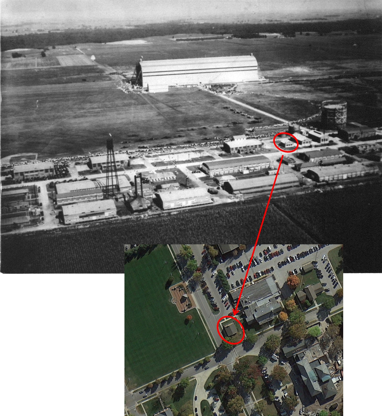
Photo credit: Upper photo, ScottAirShow.org, http://scottairshow.org/scottyears.html
Lower image: Google Earth
Making some educated guesses as to the distance the Hangar was from the 1923 building, and drawing in a rectangle the size of the hangar, I placed the hanger on what became an active runway and looks now to be a taxiway. Then in April, 2017, I received a comment from Dean P. who referred me to a 1935 topographical map of Scott Field, available on-line, and the location was fully identified! My original estimate of the location was only about 500' too far East! The properly identified location is shown here (next image). Thank you Dean P.!

Photo credit: Google Earth
So my conclusion of the approximate location of the Shenadoah on Oct 2, 1923, when it was "docked" at Scott Field is about (Lat Lon) 38.544992 -089.853405, a few hundred yards off the front of the Airship Hangar.
There remains the mystery of the giant airship hangar at Scott Field. Clearly intended as a hangar for giant rigid airship operations, they also built, in 1927, a high mast for the giants. But neither the mast nor the hangar were ever used to accommodate a great rigid. After the Hindenburg disaster, both the high mast and the hangar were destroyed. It seems, according to historian Rick Zitarosa, that the rivalry between the Navy and the Army (i.e., the Army Air Service, as the US Air Force was not yet in existence) was so strong that the Army, planning to become involved in rigid airships built the facilities at Scott Field in anticipation of Army involvement. There was speculation that the ZR-3 (designated at the U.S.S. Los Angeles) would become an Army asset but history proves that did not happen.
NAS North Point, San Diego
During her mooring tests in 1924 at NAS North Point San Diego.

Photo credit: US Navy.
So here is the NAS North Point today:
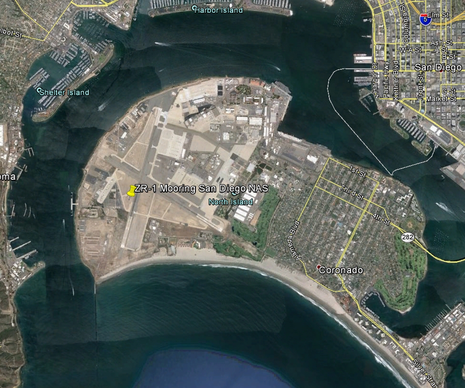
Photo credit: Google Earth
I've identified a few structures in the 1924 photo which still exist today, and before I found a terrific map of the island from 1925 I did a crude triangulation to locate where the mooring mast might have once stood. My estimate turned out to be only a few hundred yards off to the East! By locating the old map, I found the mast to have been at (Lat Lon) 32.696081 -117.217389. (Click here to View in Google Maps).
So here is the NAS North Point from that 1925 map:
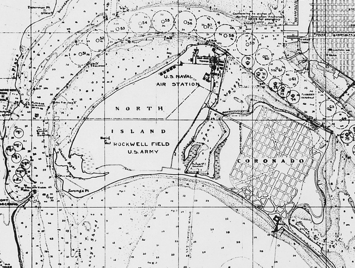
Photo credit: http://img.readtiger.com/wkp/en/San_Diego_Bay,_Plan_Showing_Anchorages_and_Moorings_-_NARA_-_295436.jpg
By lining up the map on Google Earth and matching the streets of Coronado, and the streets and buildings shown for the Naval Air Station, the location of the Mooring Mast (seen marked on the map just above and left of the "R" in "Rockwell Field") was immediately apparent.
Multiple other photos exist of the Shenandoah moored at the San Diego mast. Here are two:
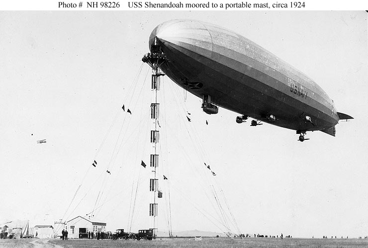
Photo credit: Naval Historical Center, http://www.history.navy.mil/photos/images/h98000/h98226.jpg

Photo credit: F. Carvallo, http://fcarvallo.deviantart.com/art/Shenandoah-1924-San-Diego-with-civilians-394986184
Long Beach, California
In October, 1924 during an ambitious 19 day trip from Lakehusrt to Texas and on to California and Washington state to test procedures and docking at newly erected mooring masts, the Shenandoah passed over Long Beach, California. The spectacular photo seen here was captured. It is not a composite. This was taken with a large format camera which used 8 x 10 inch glass plates. The original glass negative is held in the collection of the California Historical Society (CHS) at the Doheny Memorial Library in Los Angeles.
.jpg)
Photo credit: California Historical Society Collection, Public domain
https://commons.wikimedia.org/
(This photo is high resolution and can be enlarged by clicking on it.)
The photographer and the date of the photo is unknown. The description provided by the California Historical Society is only this:
Photograph of a northward view of the United States Navy dirigible USS Shenandoah over Long Beach, ca.1920. The large rigid airship is in the sky at center, headed to the left. It is a long, light-colored, rigid, blimp-like vehicle with engine pods slung underneath. A large star inlaid in a circle is painted on the side of the aircraft. Below, the tall buildings of Long Beach stretch out across the image. There is an intersection of two large streets in the lower right corner, and one of the streets is lined with early-model automobiles. A park full of tall trees and bushes is in the foreground at right.
(Love
Of course the photo is not "circa 1920", it is in fact October, 1924. And of course, I had to identify exactly where this photo was taken - it's what I do. I found another image, (reproduced below), in the California Historical Society Collection, an aerial view of Long Beach taken in 1924. A careful comparison of the aerial view with the Shenandoah photo revealed several matches of the building in both photographs so identifying the exact location of the shot proved relatively easy. I then marked several of the roads on the 1924 aerial view for reference. (Click on the photo for a larger version.)
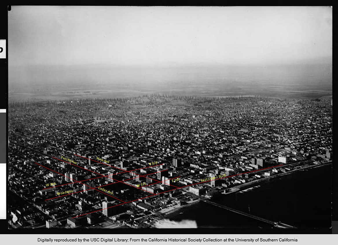
Photo credits: California Historical Society Collection
Of the identified buildings I found three that still exist today. That permitted me to not only find the exact location of the image but also the distance of the Shenandoah from the camera; the location of the camera; and make an educated estimate of the focal length lens used on the large-format camera!
Below, I've marked four buildings, 3 of which still survive today. The intersection seen in the lower-right corner of the photo but not identified in the CHS description was found to be the intersection of Cedar Ave and Ocean Blvd. (Today, Cedar Ave no longer extends all the way to Ocean Blvd.) Though Buffums' Department Store is long gone, demolished in 1985, its existence in the photo and known location in Long Beach permitted additional certainty of the location of the Shenandoah. (Note: The original name of the department store was, indeed, Buffums', with the misplaced apostrophe.)
.jpg)
Photo credits: welweb.org
In the shot above, the Shenandoah is determined to be over the intersection of Broadway and Pine Ave at the time of the photo, abt 1300 feet from the camera, at about (Lat Lon) 33.769536 -118.192367. (Click here to view the location in Google Maps).
Photo was apparently taken from an upper floor of the "Sovereign", which had been completed in 1922 likely as an office complex, at 360 W Ocean Blvd, SE side of Ocean and Chestnut, still exists today as "luxury" condominiums. Measurements reveal the 8x10 camera was apparently fitted with a lens of 150mm – 165mm in focal length based on the fact that the photo measures about 74 degrees wide and the cropping of the original photo is not exactly known. Nevertheless, at 150-165mm focal length, for this large-format camera, that was a "wide angle" shot in the era! The 680 foot long Shenandoah measures only about 1300 feet from the camera! It must have been a spectacular sight!
Shenandoah Crash Sites & Memorials
[Note: This section addresses only the crash sites. For additional Shenandoah memorial and marker sites, please see the Ava, OH section of the US monuments page.
When she came down that September day in 1925, she broke into 3 parts, creating 3 crash sites. All 3 locations are, of course, well-known. Here are the locations:
Crash Site #1

Photo credit: National Register.
http://www.flickr.com/photos/nationalregister/3972152180/
(Above.) The control car, two engines, and part of the midsection fell here near the Andy Gamary farmhouse (seen in the background) The wreckage is at (Lat Lon) 39.839108 -081.538544. (Click here to View in Google Maps).
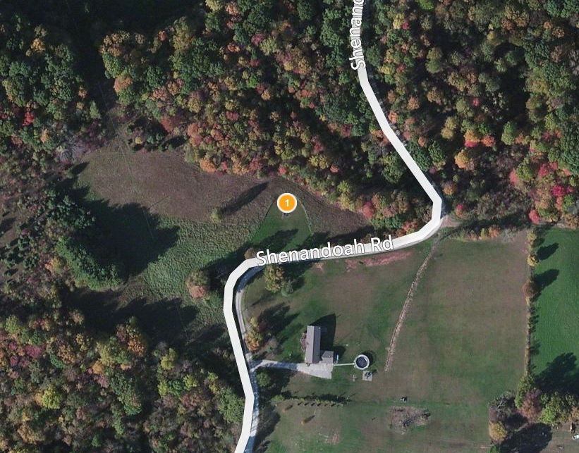
Photo credit: Bing Maps
In this image above, the location of the control car is marked by a memorial in the dead center of the image (the circle #1 in the center), and is at the Lat/Lon indicated in the previous photo.
There is no formal parking area, so one simply parks on the dirt road and walks to the site through the opening in the cable fence.

Photo credit: Michael Hughes, with permission
The memorial contains a granite marker and a crude cement marker where the body of Lt Commander Zacchary Landsdowne's body was found. (Look closely at the middle-right in the photo immediately below. A close-up of the cement marker follows this photo.) The local who created the marker in 1925 misspelling "Landsdowne". The marker reads "This is the spot of the Landowne".

Photo credit: Michael Hughes, with permission
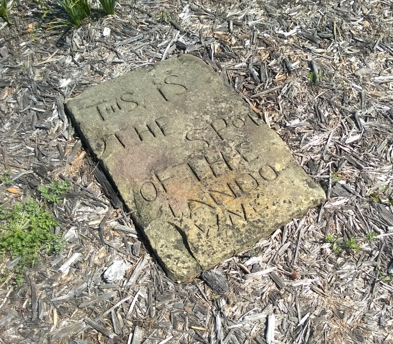
Photo credit: Michael Hughes, with permission
Crash Site #2

Photo credit: Airships.net.
http://www.airships.net/us-navy-rigid-airships/uss-shenandoah
(Above) The aft section fell near what is today Interstate 77 about 1/2 mile SW of Crash Site 1 at the Gamary farmhouse.
Below, nearly the same view today from above I-77. Compare the photo above and the one below for similarities which remain. The approximate outline of the Shenandoah's aft section is marked on the ground with painted cinder blocks.
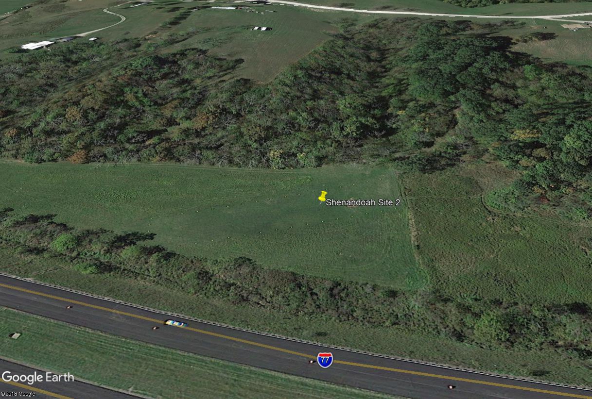
Photo credit: Google Earth.
The site is at (Lat Lon) 39.835184 -081.546320 on private property. (Click here to View in Google Maps) but the large billboard at the site is easily visible from Interstate 77:
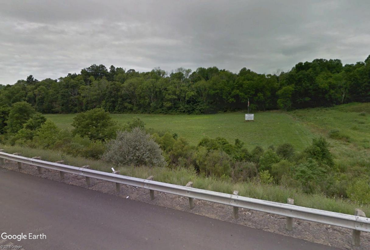
Photo credit: Google earth.
Here is the commemorative billboard as it appeared in late 2016:
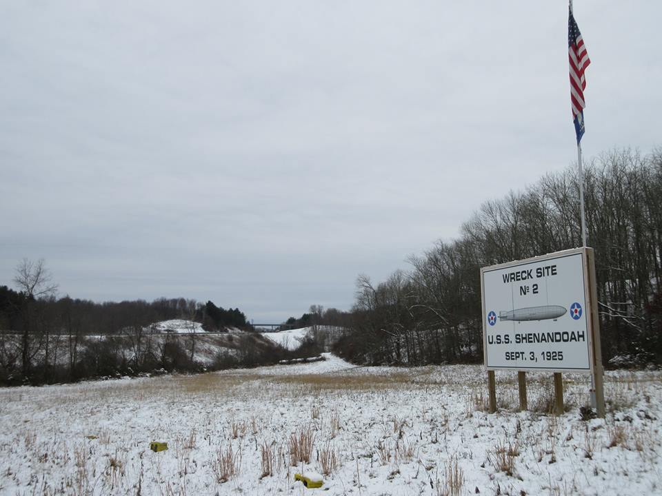
Photo credit: Jerry Copas, with permission.
Crash Site #3
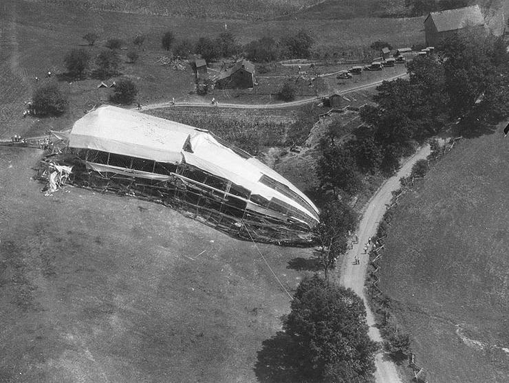
Photo credit: US Navy
http://www.history.navy.mil/photos/events/ev-1920s/ev-1925/zr1-loss.htm
(Above) Crash Site 3 is where the nose section of the Shenandoah came down. Today, one can visit the exact spot on highway 78 (also known as "McConnelsville Road") where there is a nice granite marker, and a painted sign.

Photo credit: Google Earth
(Above). This spot is also found on Google's "street view"! The map tack is at (Lat Lon) 39.741256 -081.593285. (Click here to View in Google Maps).
(Below) Here is a view of Site 3, approaching from the east on highway 78 in May, 2014:
Photo credit: Michael Hughes, with permission
Shorly after the photo above was taken, the large billboard was renewed:

Photo credit: barclaycardtravel.com
(Below) And finally, here is a close-up of the granite marker at Crash Site 3 as it looked in May, 2014. It is not known if the marker has been properly placed on its pedestal after vandals did this damage to it:

Photo credit: Michael Hughes, with permission
The Shenandoah is often mentioned as the only US Rigid Airship to crash on land. While this is true, the Roma also crashed on land, in February 1922, though the Roma was a "Semi-rigid". Both were great disasters, with tragic loss of life of many aviators. The fact that the Roma was a semi-rigid airship does not make it's disaster any less significant or of less historic interest. See my page on the Roma. But for all Airship aficionados, the Shenandoah is the one airship for which there are documented sites which can be visited including a fine memorial at Ava, OH. I wish to thank those who have contributed fine photos of the Shenandoah markers and memorials.
Again, for additional Shenandoah memorial and marker sites, please see the Ava, OH section of the US monuments page.