German Airship Graf Zeppelin (LZ-127)
LZ-127
Jump to Sites of Interest: Sønderborg Denmark * Brazil: Recife | Sao Paulo | Rio de Janeiro * Böblingen, Germany * Cologne, Germany * Frankfurt-Rebstock Airport, Germany * Friedrichshafen, Germany (2) * Speyer, Germany * Lindau, Germany * Stuttgart, Germany * Hanworth Air Park, UK * Tokyo * Los Angeles, California, USA * Detroit, MI * Oklahoma, USA

Photo credit: USC, California Historical Society
Construction
The LZ-127, christened the "Graf Zeppelin", was built in Friedrichshafen, Germany, in 1928-1929, and was patterned after the LZ-126. The LZ-126 had been built as part of WW I war reparations and given to the US Navy and commissioned as the airship USS "Los Angeles", also known as the ZR-3! The LZ-127 was launched in September, 1928.
Operations
The Graf Zeppelin operated admirably from 1928 to 1937. During that time she made 590 flights, covering more than a million miles. She made her first intercontinental flight in October, 1928, from Friedrichshafen, Germany, to Lakehurst, NJ, USA. In August, 1929, she made an around-the-world flight, beginning and ending at Lakehurst, NJ in a little more than 21 days. In March, 1936, after having been "deeded" over to the German Propaganda Ministry, the Graf Zeppelin and the newly christened Hindenburg made a four day tour of Germany dropping propaganda leaflets and being present in propaganda displays, and radio.
Demise
Sadly, when the Hindenburg burned on May 6, 1937 as it approached for landing at Lakehurst, NJ, the praising public rapidly turned against airships as a commercially viable transportation system. There was of course, a clear way to reduce the negative image of airships: by using helium rather than the flammable hydrogen Germany had been forced to use, but world helium supplies were in control by the United States. Even if Germany had appealed to the US for Helium, the expense and reduced lift (since helium is a heavier gas), would have made the Graf Zeppelin no longer viable. The day after the Hindenburg disaster, the LZ-127 was withdrawn from service, and hangared at Friedrichshafen - where it was built.
Ignominious End
On June 18th, 1937, just six weeks after the Hindenburg demise, the Graf Zeppelin made its last flight to a hangar at Frankfurt, Germany. There, the great, majestic airship was deflated, and put on display as a museum curiosity. Finally, in March, 1940, due to German aggression in WW II, the German Air Minister ordered the dismantling of the Graf Zeppelin and its aluminum airframe melted down for use in German wartime aircraft. Assuming a 5 year old in early 1940 might have gotten to see the LZ-127 on display in Frankfurt before it was destroyed, they may have had a chance to remember it. This means that no one born after 1935 would have any chance of having a memory of ever seeing one of the great airships of the early 20th century. All the rest of us must only look at old photos and videos and imagine.
Sites of Interest
Sønderborg, Denmark:
On the 14th of May, 1931, the Graf Zeppelin overflew Sønderborg, Denmark as part of its Baltic Sea tour originating from and returning to Lübeck, Germany.
On the 12th of May, the Graf left Friedrichshafen to Staaken arriving the 13th of May. From there:
Staaken (13 May) – Berlin Tempelhof (13 May)
Berlin Tempelhof (13 May) – Staaken (13 May)
Staaken (14 May) – Lübeck (14 May)
Lübeck (14 May) – Lübeck (14 May) (Round Trip over the Baltic Sea)
Lübeck (14 May) – Friedrichshafen (15 May).
On the 14th of May, the Graf Zeppelin departed Lübeck for her passenger-carrying flight over the Baltic Sea. She headed northeast toward Warnemünde then Rügen. She crossed the Baltic Sea reaching Trelleborg, Sweden and turned westward and passed over Copenhagen about noon. From Copenhagen, she continued westward to Aarhus, Denmark where she turned generally south passing Haderslev and Aabenraa in the late afternoon having followed the shoreline.
She reached the northeast side of Sønderborg and turned westerly carrying her over the Sønderborg Castle and near the King Chistian X Bridge, seen in the photo below.
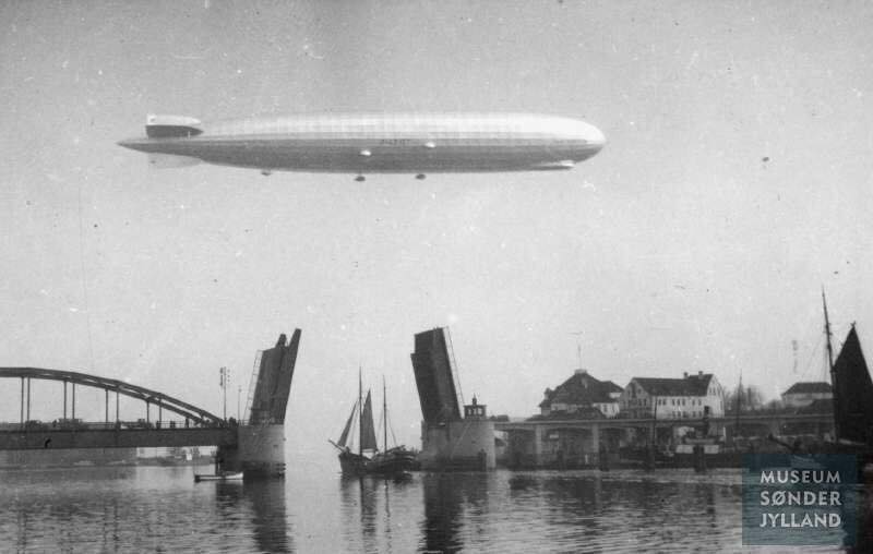
Photo credit: Museum Sønderjylland
I estimate the Graf Zeppelin in this photo is about 1000-1200 feet beyond the bridge which puts her very near the Sønderborg Castle.
So I've marked the approximate position of the Graf on the photo below as she passed by the Sønderborg Castle at (Lat Lon) 54.907706° 009.783357°.
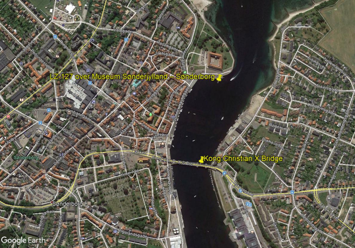
Photo credit: Google Earth
(Click here to view the location in Google Maps).Below is a fine photo of the castle and bridge taken from the Graf Zeppelin on the journey.
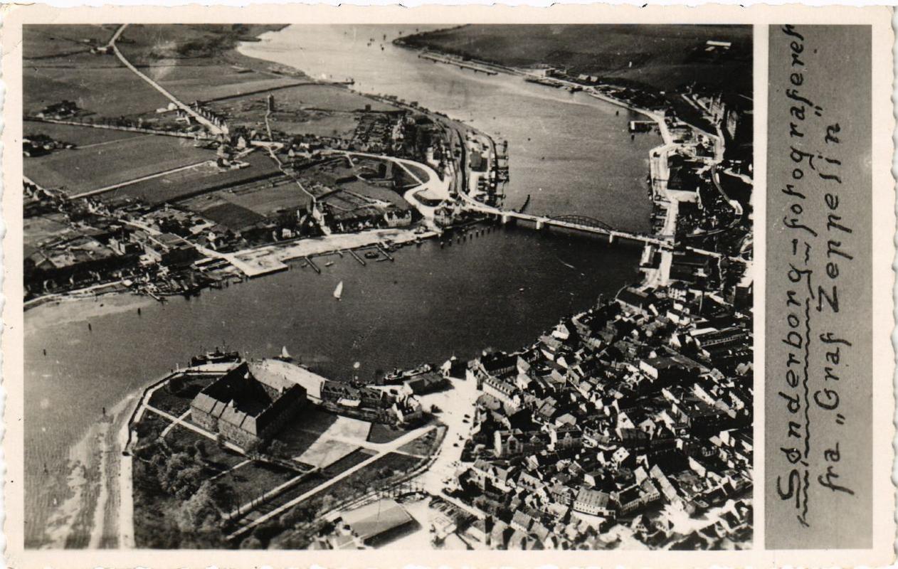
Photo credits: Unknown postcard.
And finally, here is a very fine photo of the Graf Zeppelin as she headed south after her pass by the Sønderborg Castle. This is shot from the Dybbøl Mølle (Dybbøl Mill), a famous windmill of Sønderborg which still exists today, about a mile west of the castle. In the photo, the castle is just discernible below the Graf, on the horizon, just above but beyond the peaked white roofed home, across the Alssund channel. The windmill itself is located at (Lat Lon) 54.906866° 009.758032°, if you'd like to look it up.
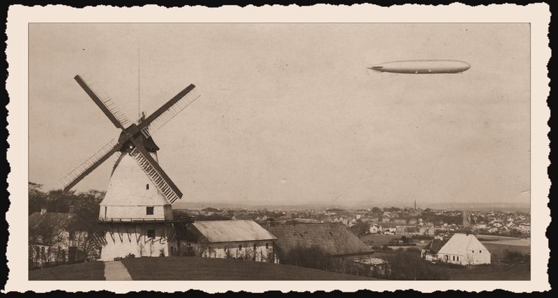
Photo credit: Unknown
Recife, Brazil:
This site would be incomplete if it did not include Recife, Pernambuco, Brazil! Recife was a regular stop in regular passenger service from Frankfurt, Germany from 1932 to 1937. The Graf Zeppelin first moored in Recife on May 22, 1930 on a journey which took the great zeppelin from Friedrichshafen to Spain, to Brazil (Recife and Rio de Janeiro, then to the United States (Lakehurst, NJ), back to Spain and finally back to Friedrichshafen.
Here is an undated shot of the Graf Zeppelin over Recife (Lat Lon) -08.060631 -034.879645, (Click here to View the exact site in Google Maps).
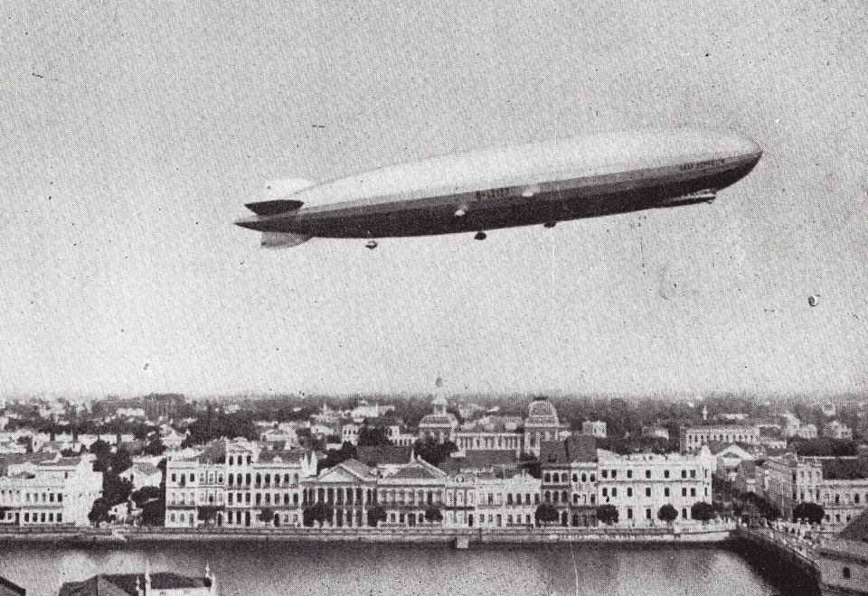
Photo credit: Public Domain
Given that the starboard fins of the Graf Zeppelin are blank in this photo, that is, they are not painted in the black, white and red tricolor German flag, this photo is very likely from the 1930 visit to Recife. By 1933, the fins were emblazoned with the Nazi tri-color on the starboard and the Nazi swastika on the port.
Here is another shot of the Graf Zeppelin over Recife. Prominent in the photo is the building known as the Palace of Justice. This building is still standing, so it made it easy to find the approximate location of the Graf Zeppelin over Recife at at moment. It is at (Lat Lon) -08.061168 -034.878131, (Click here to View the exact site in Google Maps). Notice this is a rare shot of the port side, showing the Nazi swastika on the fins so the date of this photo is sometime in 1933 to 1937 taken at a time when the Graf Zeppelin was making routing stops in Recife on its transatlantic passenger flights.

Photo credit: Public Domain
There are many shots of the Graf Zeppelin moored at Recife. I am going to reproduce two of them here. The first shot is likely from its first visit to Recife in 1930, again, since the tail fins have no markings. The second shot is later, probably 1933 or later, since the tri-color flag emblazons the starboard fins.
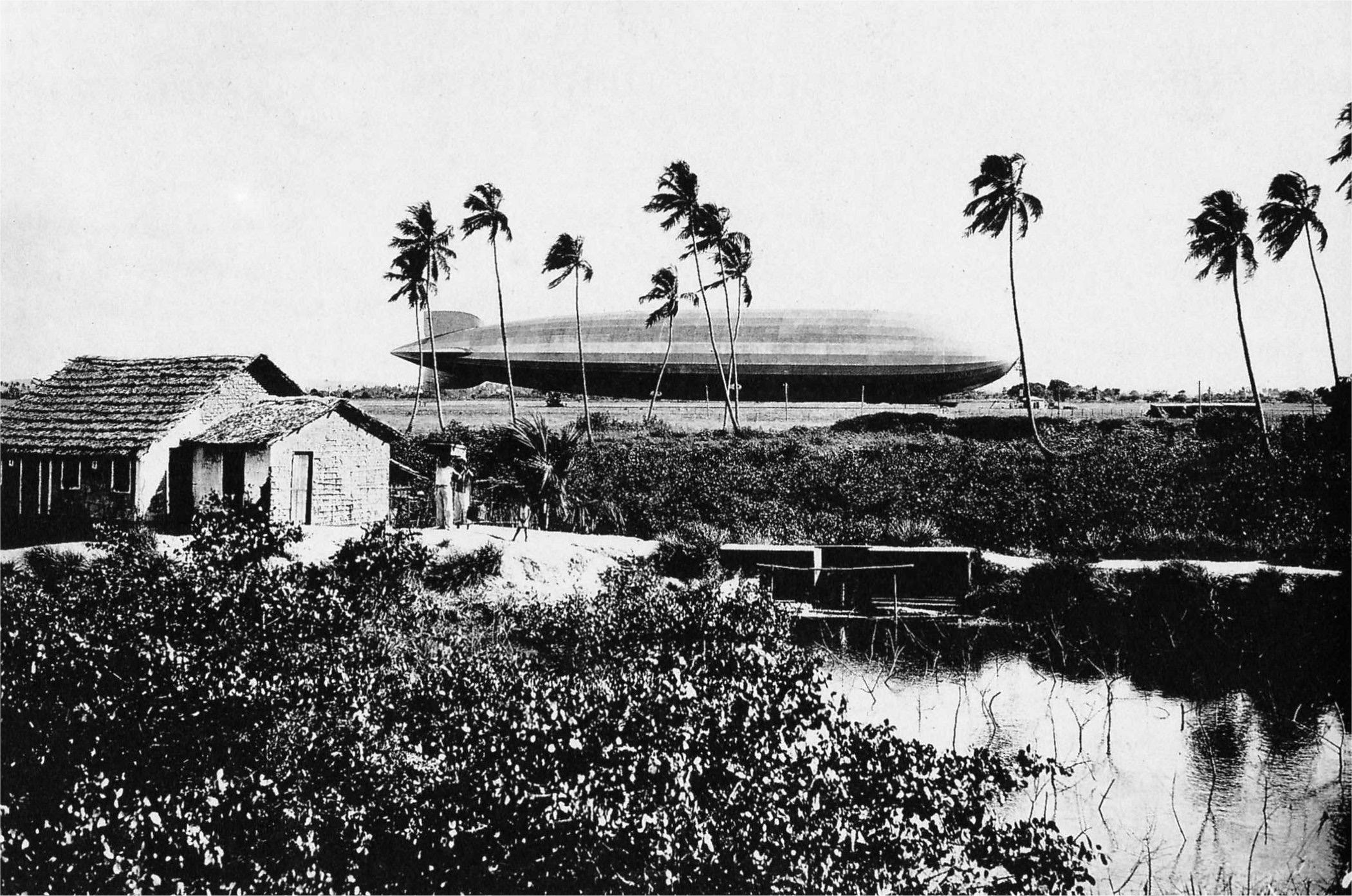
Photo credit: Public Domain
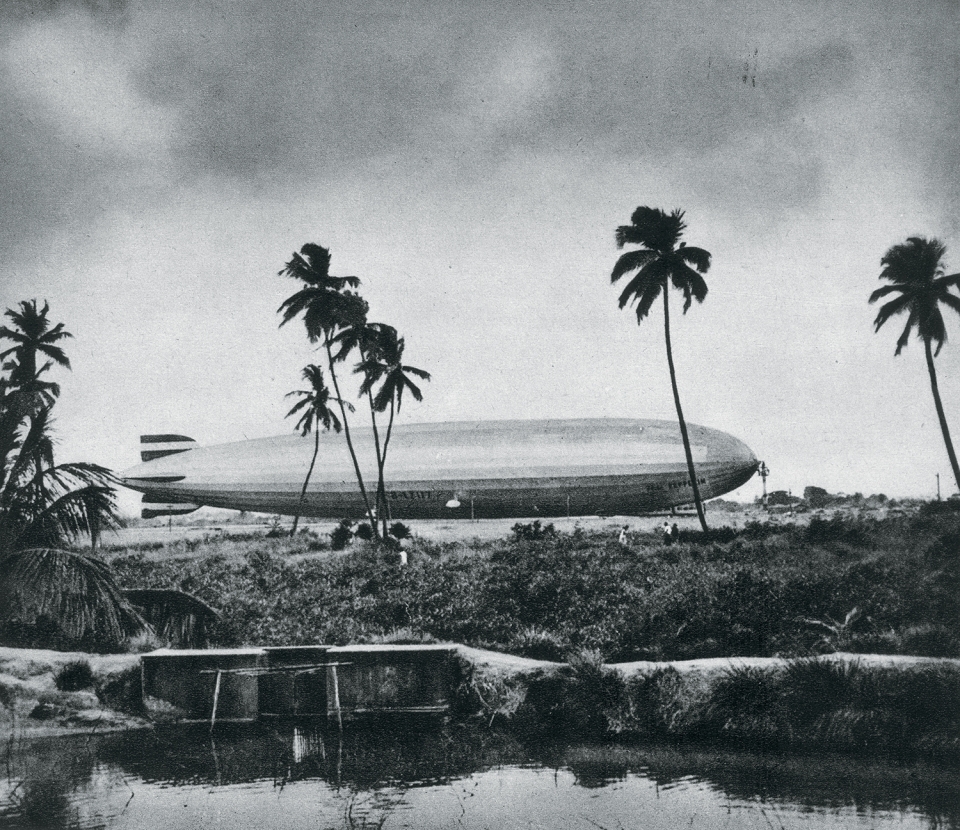
Photo credit: Public Domain
Note the mooring mast in the photos above. This mooring was built as a permanent mooring location, since there was an agreement between the German and Brazilian governments for regular commerce and landings by the Graf Zeppelin. The mast is still exists and is the only one in the world remaining! The original mast was a tower of fixed height held by guy-wires - designed specifically for the Graf Zeppelin. But the mast located at the spot today is an "upgraded" mast installed in 1937 which contains a section which can be raised or lowered to accommodate airships of varying size. The upgraded mast has stabilizing frames instead of guy-wires. Today the site is an active military base in the Parque do Jiquiá. The mast is located here: (Lat Lon) -08.078460 -034.926378. (Click here to View the exact site in Google Maps)
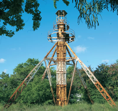
Photo credit: Public Domain
Sao Paulo, Brazil:
In this next photo the Graf Zeppelin is flying over Sao Paulo. The prominent building at the left of center with the "Vermouth Cinzano" sign on top is the Martinelli Building and it still exists, though it has been remodeled and changed somewhat from its appearance in the 1930s. (Interestingly, if you take a good under the "Vermouth Cinzano" sign and you'll see "GOODYEAR" prominently displayed!) The Martinelli Building is at (Lat Lon) -23.545556 -046.635194, and the photograph is looking East so the LZ-127 is east of the Martinelli Building over the street Praça Fernando Costa, about (Lat Lon) -23.547166 -046.631564.

Photo credit: Public Domain
Rio de Janeiro, Brazil:
I came upon this next photo of the Graf Zeppelin over Rio de Janeiro and was intrigued. I simply had to find the location. Rio de Janeiro covers a lot of area and there was not much to go by. Nevertheless, I found it. The Graf Zeppelin is flying over (Lat Lon) -22.952142 -043.186260, and the photograph is looking West. The three main roads, L-R, in the photo are: Rua Gen. Polidoro, Rua Mena Barreto, Rua Voluntarios da Patria, and Rua Sao Clemente.
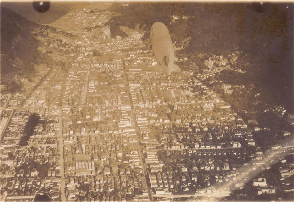
Photo credit: Public Domain
Böblingen, Germany:
I came upon this next photo of the Graf Zeppelin at Böblingen, DE on the terrific web site "Abandoned & Little-Known Airfields", (also at "http://www.forgottenairfields.com/").

Photo credit: forgottenairfields.com
The caption of this photo says "The station building and a Junkers G-38 provide scale to the immense size of LZ127 'Graf Zeppelin' during a visit in 1931." Another photo on the site identifies the date as 27 Jun, 1931.
Intrigued, I just had to study this site. I was richly rewarded.
The main buildings in this photo still exist! The building containing the control tower of the former airfield is clearly visible in this next photo made from Google Earth:

Photo credit: Google Earth
Given that this view is at a "bird's eye" perspective, I could not adjust the perspective orientation in Google Earth to match the 1931 photo, but studying the two photos, one can clearly see airfield buildings in question. Using the 1931 photo, and Google Earth, I made the following estimate of exactly where the LZ-127 was moored. ("Moored" is not correct, as there is no mooring tower, so perhaps "tied down" is better. Nevertheless, I will use the term "moored".)

Photo credit: Google Earth
The location of the map-tack in this image is at (Lat Lon) 48.693191 008.999938. Here is a Google Map of the site:
Also on the "Abandoned & Little-Known Airfields" site was the following map of the airfield from 1928:

Photo credit: forgottenairfields.com
As I like to do, I "overlaid" this 1928 photo on the Google Earth map of the area today. In the next photo, put your mouse over the image and then move it off the image to alternately see the "then and now" appearance:
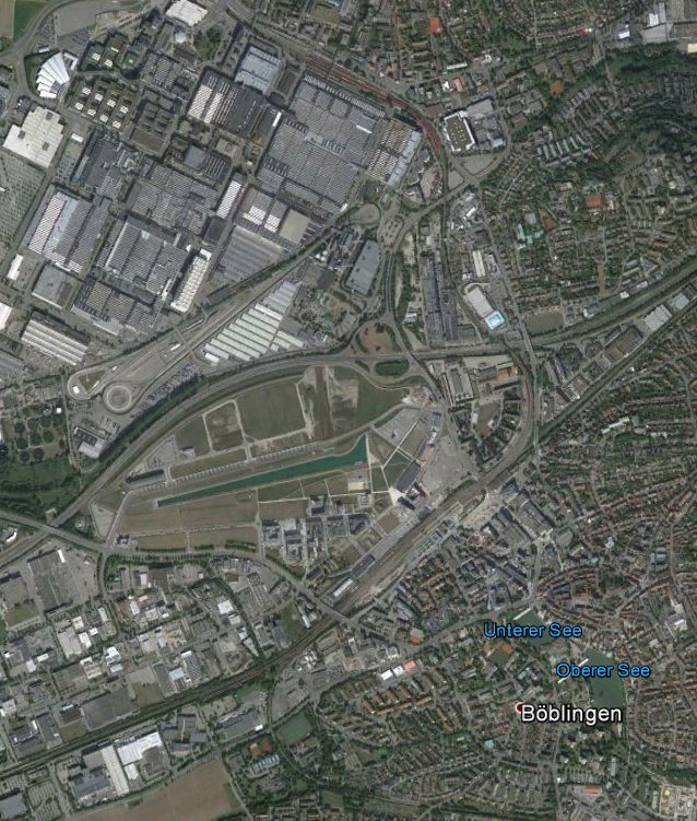
Photo credits: "Abandoned & Little-Known Airfields website" (see earlier credit) & Google Earth
Cologne, Germany:
In October, 1929, the Graf Zeppelin visited Köln (Cologne), Germany, to participate in the dedication of the Köln-Mülheim Hängebrücke (Cologne-Mulheim Suspension Bridge).
Here is a Postcard commemorating the flyover of the great airship on the 13th of October.
The bridge is at (Lat Lon) 50.964432 006.992110, (Click here to View in Google Maps).

Photo credit: http://www.koelner-luftfahrt.de/LZ_127.htm
The LZ-127 landed at the Butzweilerhof airpark for the first time on October 2nd, 1928:
.jpg)
Photo credits: W. Muller, http://www.koelner-luftfahrt.de/LZ_127.htm.
This is my estimate of where the Butzweilerhof airpark used to exist, and where the LZ-127 landed:

Photo credit: Google Earth
The map tack above is at (Lat Lon) 50.975617 006.912289, (Click here to View in Google Maps). This location is based on the description from the photo of the LZ-127 which indicates that the LZ-127 was viewed by spectators "gathered on the north by the Escherstraße, in the east at the airport and on the south Butzweilerstraße". If anyone has a better location, I'd be happy to hear from you.
The website koelner-luftfahrt.de reports that the Graf returned to Köln (Cologne) in the middle of September, 1929. Then on the flight to the Köln-Mülheim Hängebrücke, the Graf Zeppelin passed over the northwest part of Köln, and the following image was taken Oct 13, 1929 while the Graf was en route to the bridge dedication:
.jpg)
Photo credit: http://www.koelner-luftfahrt.de/LZ_127.htm
In the foreground of the photo above, is the church of St. Kunibert. To my delight, I was able to locate the church, still standing today:

Photo credits: Google Earth.
If you don't see it, this next photo clarifies:

Photo credits: Google Earth & http://www.koelner-luftfahrt.de/LZ_127.htm.
The church is at (Lat Lon) 50.946624 006.963151. (Click here to View in Google Maps).
Frankfurt-Rebstock Airport, Germany:
A very fine, hi-res, photo of the Graf Zeppelin descending for landing at the Frankfurt-Rebstock Airport in 1929:
Photo credit: https://www.fnp.de/frankfurt/frankfurthessen-winterwetter-stoert-flugbetrieb-frankfurter-flughafen-fluege-gestrichen-11131876.html
The 1909 Frankfurt-Rebstock Airport was by 1912 and airship base (Airship Base Rebstock) and was the original "Frankfurt Am-Main." Rebstock continued to operate through the 1940's but closed not long after WW II. (The modern Frankfurt Rhein-Main Airport was built as early as 1933, officially opened 8 July, 1936, and is about 5 miles (8 KM) SW of the Rebstock airport - built because as early as 1924, Rebstock was known to be too small to accommodate the growing aviation need.) On 14 July, 1936 the Graf Zeppelin landed for the first time at the new airport.
The 4-story building seen at the middle, far left in the photo above is visible in this next photo, possibly from 1925:
Photo credit: Public domain
Here's another view:
Photo credit: http://www.luftfahrtstaetten.de/luftfahrtstaetten/frankfurt-rebstock.html
Here's the location (Lat-Lon) of where the airport used to be, with the map-tack placed in the approximate location of where the Graf Zeppelin was in the first photo. It was approximately 50.108673 008.609951.
Photo credit: Google Maps
The 4-story tower seen in these photos was just to the right of the Stadt Frankfurt Kraftfahrzeug-Zulassungsstelle seen at right on the map.
Friedrichshafen, Germany:
The Graf Zeppelin was built and stationed at Friedrichshafen, Germany. Several photos, reproduced here, permitted what I believe is an accurate determination of exactly where the Friedrichshafen Airship Hangers were.

Photo credit: Oliver Easterday
Despite a pounding during WWII, buildings and churches in this photo (above) are still erect to this day and are recognizable which help locate the site in Friedrichshafen where the hangars once stood.

Photo credits: Undetermined.
And this photo (above) clinches it! The cemetery in the lower center of the photo still exists today, and provided invaluable evidence of the estimated location of the Graf Zeppelin hangars!

Photo credit: Google Earth
And here is the site! (above). The map tack is at (Lat Lon) 47.663776 009.468045, (Click here to View in Google Maps). Everything fits, from the location of the buildings and churches in the earlier photo to the geometry of the cemetery paths, the large structures in this photo are on the site of the original hangars!
Over Friedrichshafen and coast of Lake Constance
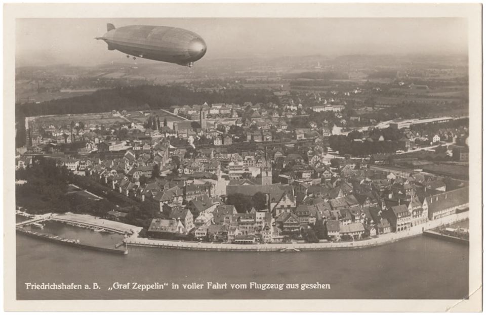
Photo credit: Postcard in the collection of Michael McMillan
The approximate same scene today:
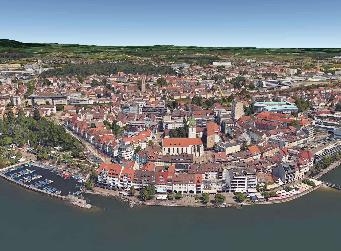
Photo credit: Google Earth
The area remains very much the same as it was despite urban renewal. Several of the properties visible in the Graf Zeppelin photo remain today.
The Graf Zeppelin, at the time of the photo, was about 1300-1400 feet over the coast of Lake Constance at (Lat Lon) 47.648739 009.478522.
Speyer, Germany:
Next, here is a photo of the Graf Zeppelin over Speyer, Germany:
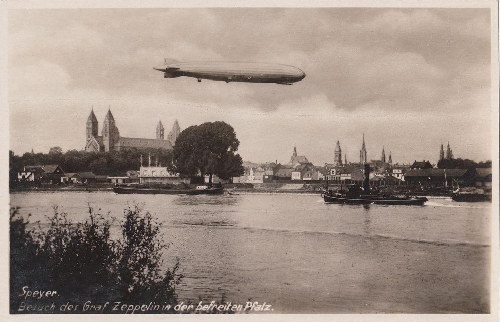
Photo credit: "breefreindly's photostream" (on FLIKR) at http://www.flickr.com/photos/violabree/with/3125221622/
No doubt this image is of the great Zeppelin over/near the great cathedral in Speyer Germany here:

Photo credit: Google Earth
The location of the map-tack in this image is at (Lat Lon) 49.317232 008.442755. (Click here to View in Google Maps).
Lindau, Germany:
Next, here is a photo of the Graf Zeppelin over the Bodensee at Lindau, Germany:
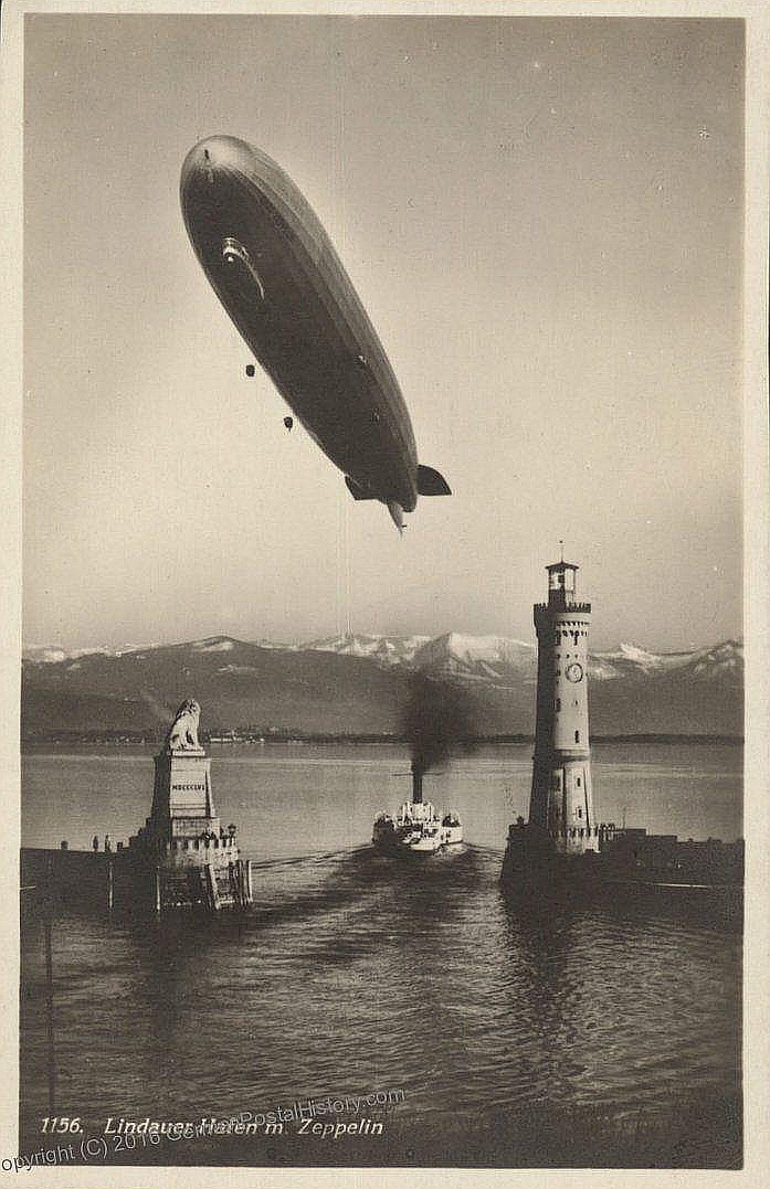
Photo credit: GermanPhotoHistory.com, http://www.germanpostalhistory.com/php/ImageServer.php?image=79862.jpg
Note on this copyright: While someone may want to purchase this postcard from GermanPostalHistory.com, the image itself is in the public domain. This image is a world historic treasure as none of us alive today can ever witness the event again! Nevertheless, if GermanPostalHistory.com asks that I remove this image, I will, and the world will have lost a wonderful thing.
Here is the same scene today:

Photo credit: Wojciech Lubian, Panoramio
And its location:
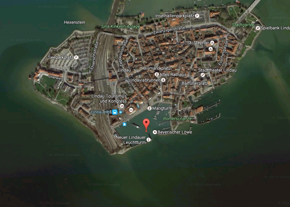
Photo credit: Google Earth
The location of the map-tack in this image is at (Lat Lon) 47.543328 009.683314. (Click here to View in Google Maps).
Here is another wonderful photo of the Graf Zeppelin over Lindau, Germany:
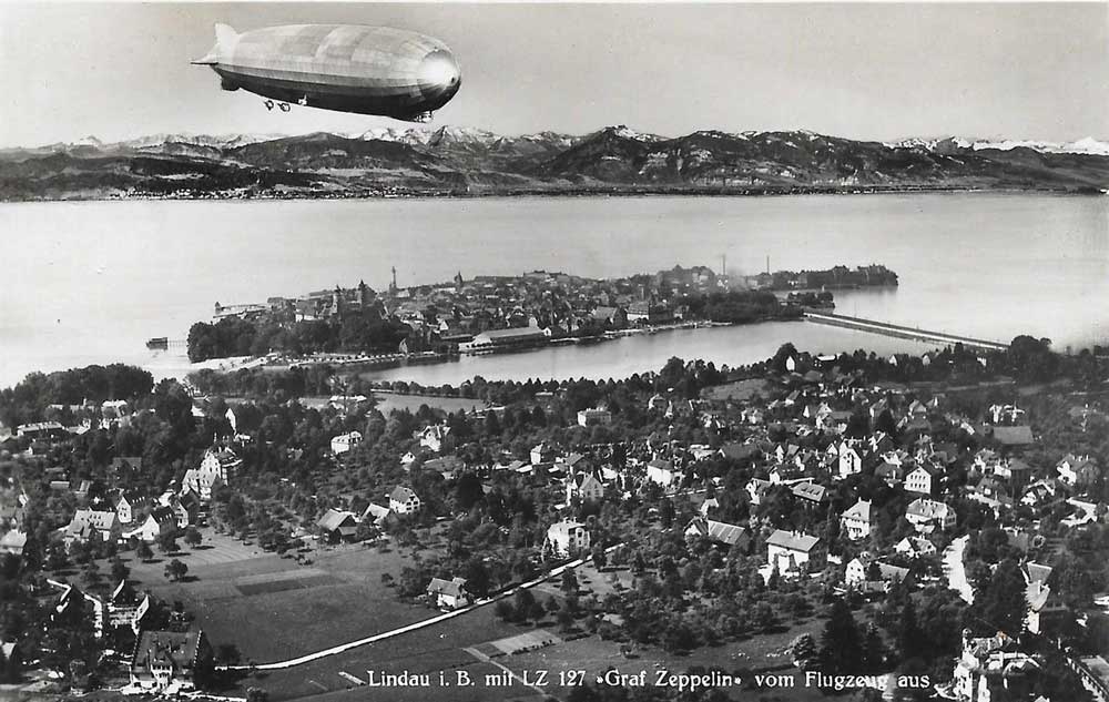
Photo credit: Old postcard, public domain
The building in the lower-left corner is still there today:
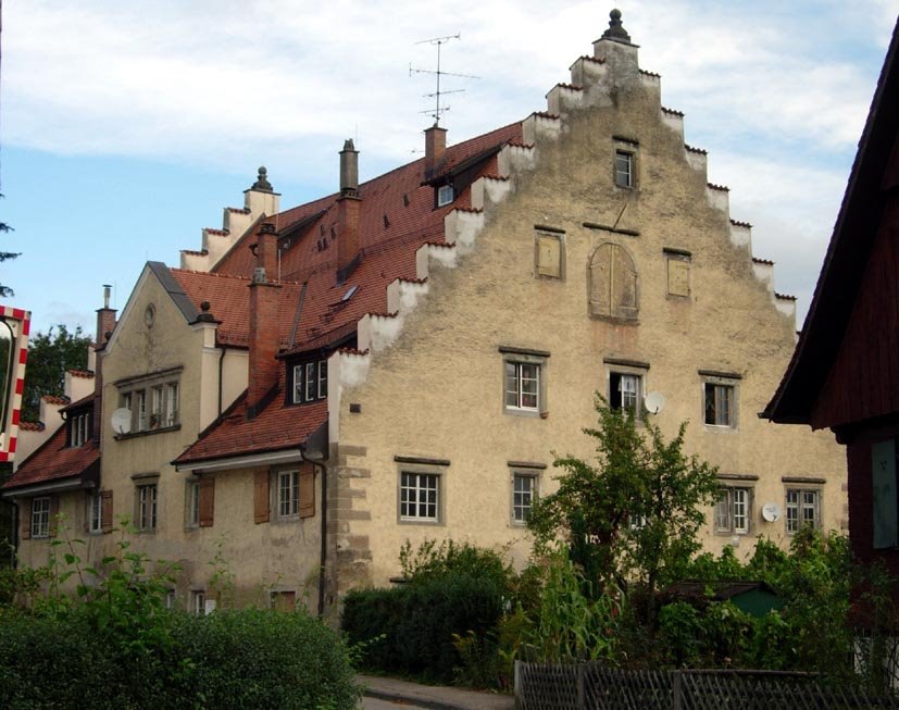
Photo credit: Abraham Ortelius, Panoramio
The location of the building is at (Lat Lon) 47.556113 009.695449:
Stuttgart, Germany:
Next, here is a photo of the Graf Zeppelin over the Stuttgart, Germany:
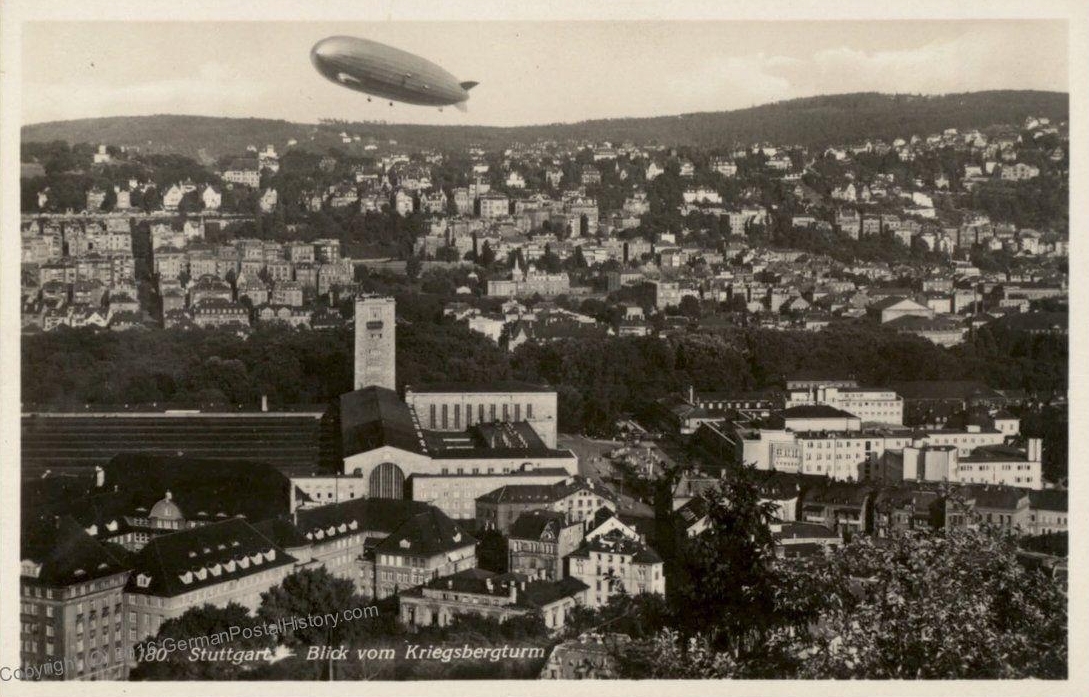
Photo credit: GermanPhotoHistory.com, http://www.germanpostalhistory.com/php/viewitem.php?itemid=79861&germany%20cover=search&
Note on this copyright: While someone may want to purchase this postcard from GermanPostalHistory.com, the image itself is in the public domain. This image is a world historic treasure as none of us alive today can ever witness the event again! Nevertheless, if GermanPostalHistory.com asks that I remove this image, I will, and the world will have lost a wonderful thing.
Here is the same scene today from a slightly higher perspective:
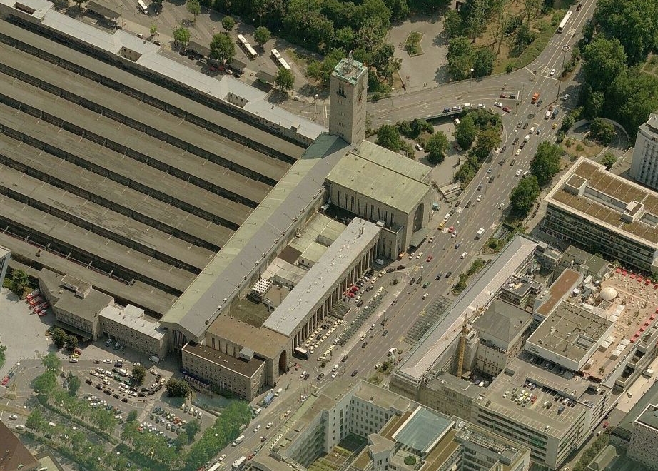
Photo credit: Bing Maps
And its location:
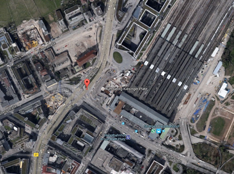
Photo credit: Google Earth
The location of the map-tack in this image is at (Lat Lon) 48.784353 009.179325. (Click here to View in Google Maps).
Hanworth Air Park, UK:
Next, here is a photo of the Graf Zeppelin visiting the Hanworth, UK Air Park:

Photo credit: Airships Online at
http://www.airshipsonline.com/airships/LZ127_Graf_Zeppelin/images/GrafZeppelin.jpg
Here is another fine photo of the Graf Zeppelin parked at Hanworth:
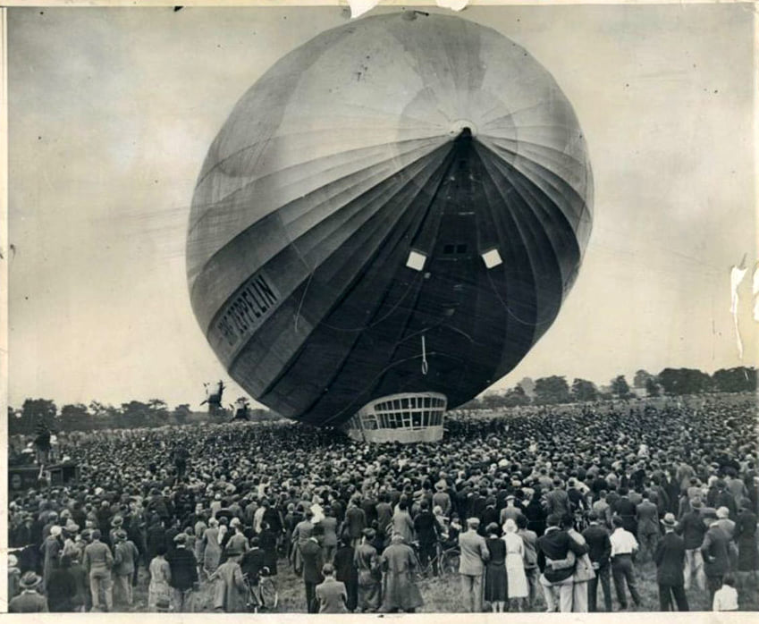
Photo credit: Airships Online at
http://www.airshipsonline.com/airships/LZ127_Graf_Zeppelin/images/GrafZeppelin.jpg
Though the Hanworth Air Park closed in 1947, it is still an open space today and the Hanworth Park House is still present. This made it easy to determine the approximate mooring location of the great Zep! Courtesy of Google Earth, here is Hanworth today:
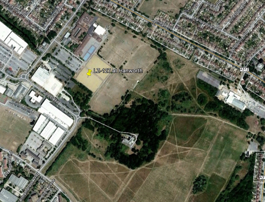
Photo credit: Google Earth
The location of the map-tack in this image is at (Lat Lon) 51.442337 -000.400643. (Click here to View in Google Maps).
Tokyo:
Next, here is a photo of the Graf Zeppelin over Tokyo on its way to Kasumigaura Airport during the around-the-world flight, on August 19, 1929:
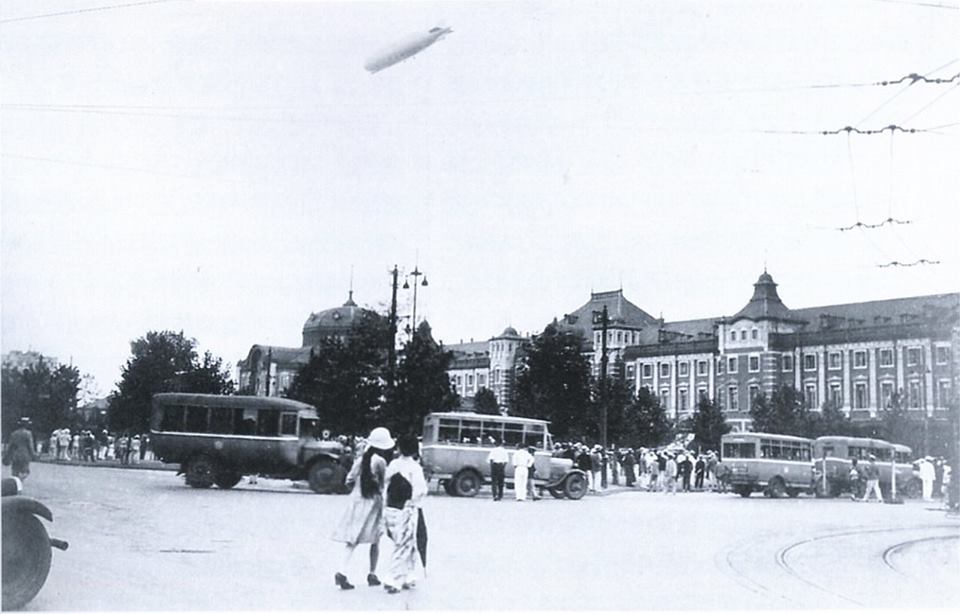
Photo credit: Public Domain
The building seen dominating the photo is Tokyo Station. Here it is today:
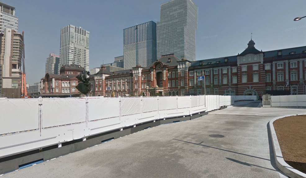
Photo credit: Google Earth
The location of the map-tack in this image is at (Lat Lon) 35.681190 139.764908. (Click here to View in Google Maps).
I have a couple of other photos of the Graf over Tokyo of which I am working on identifying the locations. I will post them here if I am successful!
Los Angeles, California, USA:
I found great photos of the LZ-127 on the ground in Los Angeles in 1929, and studied the images to find the location its mooring. At that time, what became the Los Angeles International Airport was known as "Mines Field". Though nothing in this photo (next) identifies the location, I was able to find a photo which did!
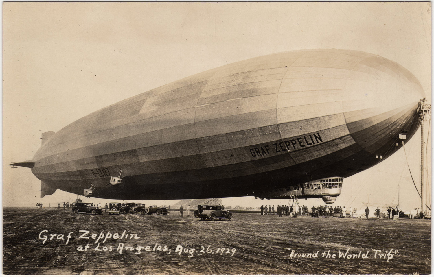
Photo credit: Airships.net, http://www.airships.net/lz127-graf-zeppelin/history
Here is the photo which clinched the location:

Photo credit: South Bay History, http://www.insidesocal.com/history/2010/06/the-graf-zeppelin.html
By a careful study of the next two photos, along with making measurements which could be reproduced in Google Earth, I believe I've made a fairly accurate identification of the precise location of the mooring mast which was at what was then called the "Los Angeles Municipal Airport":

Photo credit: LAX Master Plan, 2003, Plate S3
This photo (above) is described in the LAX Master Plan as "circa 1929". But we know the Graf Zeppelin visited LA Municipal in Aug, 1929, and at that time the apparent aircraft parking apron seen in in front of hangars 1-3 is not present in the Graf Zeppelin shot. So this photo very likely late 1929 or early 1930. However, in this shot, the road along the West side in the Graf shot, along which many dozens of cars are parked, is apparently not present in this photo! (Note the absence of telephone poles in this photo which are present in the Graf photo.) But it is striking how many features in this photo are discernible in the 1929 photo of the Graf Zeppelin moored in August of 1929.
And this next photo, Plate S4 from the LAX Master Plan, 2003, shows Hangar 1 along with Hangar 2 & 3 looking to the Northeast, probably taken well after plate S3, since there are now more buildings west of Hangars 2 & 3. But still, what is now W. Century Blvd, is not clearly present, even though it was present in the Graf photo, which was clearly taken earlier!:

Photo credit: LAX Master Plan, 2003, Plate S4
This photo (above) is described in the LAX Master Plan as "circa 1929", but clearly it is later than 1929 as we know the Graf Zeppelin visited LA Municipal in Aug, 1929, and at that time the field was much less developed. So this photo is more likely sometime in 1930.
And finally, my findings are presented in the next photo, from Google Earth, with a map tack placed where I believe the Graf Zeppelin's mooring mast once stood:

Photo credit: Google Earth
I've marked the location of Hangar 1, and the location of the mooring mast. The map tack for the Mooring site is at (Lat Lon) 33.941712 -118.381820. (Click here to View in Google Maps). I've positioned it far enough from Aviation Blvd, to account for the distance from the tail of LZ-127 as seen in the aerial photo above. Also, though Century Blvd did not yet exist, the road on which most cars parked that August in 1930 became Century Blvd, and I've placed the mast site approximately the right distance from it.
Detroit, MI:
Next, is a photo of the Graf Zeppelin over Detroit, Michigan:
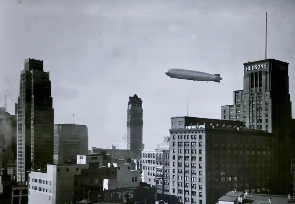
Photo credit: Public Domain
The building seen dominating the photo is Hudson's Department store, demolished in 1998, which was located at (Lat Lon) 42.333697 -083.047771.
The other two skyscrapers in the photo still exist today! The Graf Zeppelin, at the time of the photo was approximately over (Lat Lon) 42.338868 -083.058794, about 1/2 mile NW of the Hudson Department Store.
Oklahoma, USA:
This investigation diverges a bit from my usual intent, that of identifying the location of a photo of an airship and finding that exact spot today. In August, 1929, the great Graf Zeppelin, concluding its "Round the World" trip, passed over Oklahoma! This was interesting to me for two reasons. First, I grew up in Enid, OK, and the fact that the Graf Zeppelin passed so near Enid in 1929 is most compelling to me! Even though I was not even born till 24 years after this amazing event took place, it is still fascinating to me that this is my closest connection to this tremendous era of lighter-than-air that I missed. Second, the American airship USS Los Angeles passed over Tulsa, OK in October, 1928, yet the historical record of the Los Angeles visit in 1928 has become confused with the 1929 Graf Zeppelin pass through Oklahoma. For a long time I studied the flights of the Los Angeles to see if it had possibly visited Tulsa twice! It did not! So it was satisfying to discover that the confusion is likely due to these two newsworthy events of two separate great airships happening within a year of each other!
I pieced together several newspaper reports and created a map of the likely path of the Graf Zeppelin over Oklahoma on that morning in 1929, the 28th of August. The Graf was diverted over Oklahoma on its way to New York at the end of its world flight because Oklahoma Senator Elmer Thomas had petitioned the German government to fly the Graf over Oklahoma City to aide in the burgeoning aviation industry in Oklahoma. Unfortunately, the airship was pushed by winds a bit too far north and west of Oklahoma City that morning, and though the Graf Zeppelin made a large circle over what they thought was Oklahoma City, they in fact circled a large areas of land south of Perry, OK! (This is very near my home town of Enid). The newspaper Oklahoman reported the next morning: "at least a dozen towns in Oklahoma got a glimpse of the Zeppelin. Entering the state in southwestern Beckham county, the big ship flew over Carter, Elk City, Clinton, Arapaho, Thomas, Watonga, Kingfisher, Hennessey, Perry, Mulhall, Ponca City and Fairfax” before it left Oklahoma headed for Kansas City."
W.B. Estes in September, 1929, reported that in a letter he received from Dr. Hugo Eckener said "I was lost, but then I was lost since we left Los Angeles two hours behind." He went on to explain that he had tried to maintain a course to pass over Oklahoma City, and he thought he was circling El Reno on the morning of the 28th, but was actually over Perry, Marshall and Mulhall Oklahoma.
So with various newspaper reports, some of which provided times of the passing over various cities and towns, I pieced together the following flight path. (You can right-click on this image and select "view" or "save" for a full-sized version):

Photo credit: Google Earth
Though I could only draw straight-line segments between towns and I have no way of knowing how close to each town the Graf actually passed, at about 1000 feet altitude, along with the Graf's enormous size and noise, ground observers from miles around would have been able to see it in the early morning sun. I've placed a circle over Perry, Mulhall, and Marshall as it is reported this is where the Graf loitered in a great circle thinking they were near Oklahoma City, but obviously, this, too, is just a guess.
This was truly a joy to find and research the locations of these sites where the great Graf Zeppelin was seen. I hope you enjoyed it!